
Every point on Earth has a unique address defined by its geographic coordinates—latitude and longitude. Whether you're planning a hike, marking a property boundary, or geotagging a photo, knowing how to find accurate coordinates is an essential digital skill. For beginners, the process may seem technical, but with the right tools and understanding, it becomes straightforward. This guide walks through practical methods, common pitfalls, and expert-backed techniques to help you retrieve precise location data from any device.
Understanding Coordinates: Latitude and Longitude
Before retrieving coordinates, it's important to understand what they represent. The global coordinate system uses two values: latitude and longitude. Latitude measures how far north or south a point is from the equator (0°), ranging from 90°N at the North Pole to 90°S at the South Pole. Longitude measures east-west position relative to the Prime Meridian in Greenwich, England, ranging from 180°W to 180°E.
Coordinates are typically expressed in one of three formats:
- Degrees, Minutes, Seconds (DMS): e.g., 40°26′46″N 79°58′56″W
- Decimal Degrees (DD): e.g., 40.4461° N, -79.9822° W
- Degrees and Decimal Minutes (DMM): e.g., 40°26.766′N, 79°58.933′W
Most digital tools use Decimal Degrees because they’re easier for software to process. However, some navigation devices and older maps still rely on DMS, so being able to interpret all formats is useful.
Step-by-Step Guide to Finding Coordinates
Accurately retrieving coordinates involves selecting the right tool and following a consistent method. Below is a reliable five-step process applicable across platforms.
- Choose your method: Decide whether you’ll use a smartphone app, web-based map, or dedicated GPS device based on your needs and environment.
- Navigate to your target location: Use search, zoom, or physical movement to pinpoint the exact spot.
- Select or tap the location: On digital maps, click or long-press to place a marker.
- Retrieve the coordinates: Access the location details to view latitude and longitude.
- Record and verify: Save the data in your preferred format and double-check accuracy.
This sequence works whether you're identifying a remote trailhead or confirming the location of a business address. Accuracy improves when you zoom in closely and avoid estimating positions between landmarks.
Using Google Maps to Find Coordinates
Google Maps is one of the most accessible tools for beginners. It’s free, widely available, and supports both desktop and mobile platforms.
On Desktop:
- Go to maps.google.com.
- Search for an address or manually navigate to a location.
- Right-click the exact point on the map.
- In the pop-up menu, select “What’s here?”
- At the bottom of the screen, a card will display the coordinates in Decimal Degrees.
- Click the coordinates to copy them automatically.
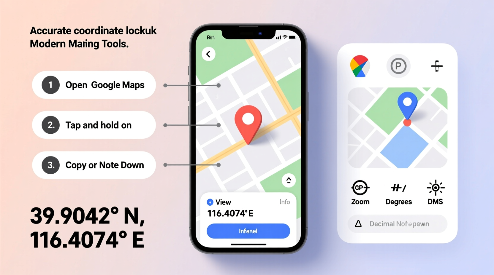
On Mobile (Android/iOS):
- Open the Google Maps app.
- Tap and hold the location until a red pin drops.
- A search bar at the top will show the approximate address and coordinates.
- Tap the coordinate link at the bottom to open the full location card.
- Tap the coordinate string to copy it to your clipboard.
The mobile version often shows coordinates in DMS format first but allows switching to DD in settings or via third-party apps that integrate with Google Maps.
| Method | Accuracy | Best For |
|---|---|---|
| Google Maps (desktop) | High (within 1–3 meters) | Precise planning, research |
| Google Maps (mobile) | Moderate to High | On-the-go lookups |
| Dedicated GPS receiver | Very High (sub-meter) | Hiking, surveying |
| Smartphone GPS | Variable (5–15 meters) | General navigation |
Alternative Tools and Advanced Tips
While Google Maps is user-friendly, other tools offer enhanced precision or specialized features.
- GPS Compass Apps: Apps like \"GPS Status & Toolbox\" (Android) or \"Crazy Horse GPS\" (iOS) display real-time coordinates, altitude, and satellite signal strength. These are ideal when high precision is needed.
- USGS Topo Maps: The U.S. Geological Survey provides detailed topographic maps with built-in coordinate overlays, useful for hikers and land surveyors.
- Geoportals: Government mapping services like The National Map allow coordinate lookup with verified geospatial data.
For fieldwork, enabling high-accuracy mode on smartphones (using GPS, Wi-Fi, and Bluetooth) improves location fidelity. Also, waiting 30–60 seconds after acquiring a GPS fix reduces drift and enhances accuracy.
“Always cross-reference coordinates using at least two sources—especially in remote areas where signal errors are more common.” — Dr. Alan Reyes, Geospatial Scientist at Oregon State University
Real-World Example: Locating a Trailhead in the Rockies
Sarah planned a solo backpacking trip to a lesser-known trail near Durango, Colorado. The trail wasn’t well marked, and her paper map lacked precise waypoints. Using her phone, she opened Google Maps and searched for “Haviland Lake Trailhead.” The result was slightly off—near a road junction but not the actual starting point.
To refine her location, she switched to satellite view, zoomed in, and dropped a pin exactly where the footpath began. The coordinates appeared as 37.3422° N, -107.8845° W. She saved these in her notes and imported them into her handheld Garmin GPS. During the hike, she periodically checked her current position against the saved waypoint, staying on course despite intermittent tree cover.
By combining online tools with field verification, Sarah avoided getting lost—a common issue among hikers who rely solely on vague descriptions.
Common Mistakes and How to Avoid Them
Even simple coordinate lookups can go wrong if basic errors aren’t addressed. Here are frequent issues and their solutions:
- Misreading positive/negative signs: A negative longitude indicates west; forgetting this can place you on the wrong continent.
- Confusing coordinate formats: Entering DMS values into a DD-only system causes large positioning errors.
- Trusting unverified sources: Crowdsourced maps sometimes have outdated or incorrect pins.
- Ignoring elevation: While not part of standard coordinates, altitude matters in mountainous or aerial navigation.
Always verify coordinates by searching them back into a map. If the pin drops in the middle of a lake instead of a campsite, something’s wrong.
Frequently Asked Questions
Can I get coordinates without an internet connection?
Yes. Smartphones with GPS enabled can determine your current location offline using satellite signals. Pre-downloaded maps in apps like Gaia GPS or OsmAnd also support coordinate lookup without data.
Why do my coordinates change slightly over time?
Minor fluctuations are normal due to GPS signal drift, atmospheric conditions, or device calibration. For critical applications, average multiple readings or use differential GPS tools.
Are coordinates the same as an address?
No. An address is a human-readable label (e.g., “1600 Pennsylvania Ave”), while coordinates are precise numerical positions. However, addresses can be converted to coordinates through geocoding—a feature used by mapping services.
Final Checklist Before You Go
Before relying on any coordinate data, run through this quick verification checklist:
- ✅ Confirm the coordinate format (DD, DMS, or DMM).
- ✅ Ensure correct hemisphere signs (+/- or N/S, E/W).
- ✅ Cross-check with a second tool (e.g., verify Google Maps results in Apple Maps or USGS).
- ✅ Test by entering the coordinates back into the map to see if they drop the pin correctly.
- ✅ Save backups in multiple places (notes, email, GPS device).
Conclusion
Knowing how to accurately look up coordinates opens doors to better navigation, safer outdoor adventures, and more precise data collection. From using everyday tools like Google Maps to leveraging advanced GPS apps, the process becomes intuitive with practice. Accuracy doesn’t come from technology alone—it comes from understanding the system, verifying results, and applying best practices in real-world conditions.


 浙公网安备
33010002000092号
浙公网安备
33010002000092号 浙B2-20120091-4
Comments
No comments yet. Why don't you start the discussion?