
Triangulation is a powerful method used to determine the precise location of a mobile phone by analyzing its signal strength and timing across multiple cell towers. While commonly associated with emergency services and law enforcement, understanding this process can be valuable for network engineers, security professionals, and even curious tech enthusiasts. This guide breaks down the science behind mobile triangulation and provides a clear, actionable framework to estimate a device’s geographic position with high accuracy.
Understanding the Basics of Mobile Triangulation
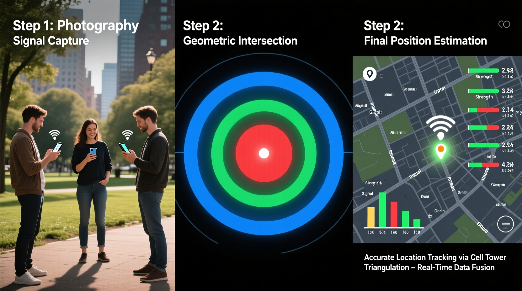
Mobile phone triangulation—more accurately referred to as multilateration—relies on measuring the distance between a mobile device and at least three cellular base stations. Unlike GPS, which uses satellite signals, triangulation leverages the existing cellular network infrastructure. When a phone is powered on and connected to a network, it continuously communicates with nearby towers, sending and receiving radio frequency (RF) signals.
The system calculates location based on one or more of the following metrics:
- Time Difference of Arrival (TDOA): Measures how long it takes for a signal to reach different towers.
- Angle of Arrival (AOA): Determines the direction from which the signal reaches a tower using directional antennas.
- Received Signal Strength Indicator (RSSI): Estimates distance based on signal attenuation over distance.
While no single method offers perfect accuracy, combining them significantly improves reliability. Urban areas with dense tower coverage typically yield results within 50–100 meters, while rural regions may have margins of error exceeding several kilometers.
Step-by-Step Guide to Triangulating a Mobile Phone’s Position
Accurate triangulation requires technical access and careful calculation. Below is a structured approach suitable for authorized personnel or network analysts working within legal boundaries.
- Verify Network Access and Legal Authorization
Before initiating any tracking, confirm you have lawful permission. Unauthorized location tracking violates privacy laws in most jurisdictions. - Identify Active Cell Towers
Use a network diagnostic tool or carrier API to detect all towers currently communicating with the target device. Note each tower’s unique identifier (Cell ID), geographic coordinates, and antenna orientation. - Collect Signal Data
Gather time-stamped measurements including:- Signal arrival time at each tower
- Signal strength (RSSI in dBm)
- Frequency band and channel used
- Calculate Distances
Using the speed of light (~300,000 km/s), compute approximate distances from the phone to each tower based on signal travel time. For RSSI-based estimation, apply propagation models like the Log-Distance Path Loss model, adjusted for urban or rural environments. - Plot Intersections on a Map
Draw circles centered on each tower with radii equal to the calculated distances. The point where all three (or more) circles intersect is the estimated location. In practice, due to measurement errors, these circles rarely meet perfectly—use centroid averaging or least-squares estimation to find the most probable position. - Refine Using Environmental Data
Adjust for known obstacles such as tall buildings, hills, or weather conditions that affect signal propagation. Machine learning models trained on local RF behavior can further enhance precision.
Tools and Technologies Used in Real-World Triangulation
Professionals use specialized hardware and software to perform reliable triangulation. Common tools include:
| Tool | Purpose | Example Use Case |
|---|---|---|
| StingRay Devices | Simulate cell towers to capture signal data | Law enforcement tracking during investigations |
| OpenBTS + USRP | Build custom GSM networks for monitoring | Network testing and research |
| Wireshark with LTE support | Analyze raw signaling messages | Detecting anomalies in handover patterns |
| GIS Mapping Software (e.g., QGIS) | Visualize tower locations and intersection points | Emergency response planning |
Carrier-grade systems often integrate triangulation into their Location Services Gateways (LSGs), automatically processing data from multiple sources to deliver real-time positioning without user intervention.
“Modern cellular networks are designed with redundancy and overlapping coverage not just for reliability—but also to enable robust geolocation when needed.” — Dr. Alan Reyes, Senior Telecommunications Engineer at NIST
Real-World Example: Locating a Missing Person
In 2021, a hiker went missing in the Sierra Nevada mountains after losing trail markers. Local authorities obtained a warrant to access the individual’s mobile carrier data. Engineers analyzed pings from three nearby towers operated by different carriers, noting inconsistent signal strengths due to terrain blockage.
By applying TDOA calculations and overlaying topographical maps, they identified a narrow valley where signal shadows converged. Search teams were dispatched to that area and located the hiker within two hours, suffering from mild hypothermia but alive. The success was attributed to precise triangulation combined with terrain-aware modeling.
This case underscores both the life-saving potential and technical complexity of mobile location tracking. It also highlights the importance of integrating external data—such as elevation and vegetation density—to correct for signal distortion.
Common Challenges and How to Overcome Them
Despite its utility, triangulation faces several limitations:
- Tower Density: Sparse coverage leads to large uncertainty zones.
- Multipath Interference: Signals bouncing off structures distort timing and strength readings.
- Device Power State: Phones in sleep mode transmit less frequently, reducing data availability.
- Network Handovers: Rapid switching between towers complicates continuous tracking.
To mitigate these issues:
Frequently Asked Questions
Can I triangulate a phone using only GPS data?
No. GPS determines location via satellites, not cell towers. Triangulation specifically refers to using terrestrial network signals. However, hybrid systems often fuse GPS, Wi-Fi, and cellular data for optimal accuracy.
Is it possible to triangulate a turned-off phone?
Generally, no. A powered-off phone does not emit signals. However, some advanced forensic techniques may detect residual power states or brief reconnections during boot-up if monitored in real time.
How accurate is mobile phone triangulation?
Accuracy varies widely: 50–100 meters in cities with dense tower coverage, up to 1–5 kilometers in rural areas. Advanced methods like Uplink Time Difference of Arrival (U-TDOA) can achieve sub-50-meter precision under ideal conditions.
Actionable Checklist for Effective Triangulation
Follow this checklist to ensure a methodical and effective triangulation process:
- ✅ Obtain proper legal authorization before accessing location data
- ✅ Identify at least three active cell towers linked to the device
- ✅ Record precise timestamps and signal metrics (RSSI, timing advance)
- ✅ Use mapping software to plot distance circles around each tower
- ✅ Apply correction factors for environmental interference
- ✅ Cross-reference with other location sources (GPS, Wi-Fi, IMEI logs)
- ✅ Document all steps and data sources for auditability
Conclusion: Mastering Precision in Mobile Location Tracking
Triangulating a mobile phone’s position is not magic—it’s applied physics, mathematics, and network intelligence. When executed correctly and ethically, it becomes a vital tool for public safety, network optimization, and personal security. The key lies in understanding the underlying principles, leveraging the right tools, and respecting legal and privacy boundaries.


 浙公网安备
33010002000092号
浙公网安备
33010002000092号 浙B2-20120091-4
Comments
No comments yet. Why don't you start the discussion?