
Navigating without GPS may seem outdated in an age of smartphones and satellite guidance, but the ability to read a map remains a vital skill. Whether you're hiking remote trails, preparing for emergencies, or exploring unfamiliar cities, understanding how to interpret topographic maps, orient yourself, and follow routes builds self-reliance and sharpens spatial awareness. Unlike digital tools, paper maps don’t rely on batteries or signal strength—making them indispensable when technology fails.
Beyond utility, map reading fosters a deeper connection to the landscape. It encourages observation, patience, and problem-solving. With practice, anyone can learn to extract rich information from lines, symbols, and contours, transforming abstract markings into a clear mental picture of terrain and direction.
Understand Map Types and Their Uses
Not all maps serve the same purpose. Choosing the right type is the first step toward effective navigation.
- Topographic maps: Show elevation, terrain features, and landforms using contour lines. Ideal for hiking, climbing, and backcountry travel.
- Road maps: Focus on highways, streets, and points of interest. Best for driving and urban navigation.
- Trail maps: Simplified versions highlighting footpaths, campsites, and trailheads. Common in parks and recreational areas.
- Nautical charts: Designed for marine navigation, showing water depths, buoys, and coastal landmarks.
- Political maps: Emphasize borders, cities, and administrative divisions—useful for general geography but not for field navigation.
For outdoor enthusiasts, the U.S. Geological Survey (USGS) topographic series and Ordnance Survey (UK) maps are gold standards. They provide detailed elevation data, accurate scale, and standardized symbology.
Decipher Key Map Elements
A map is more than just a picture of land—it’s a coded system that requires interpretation. Master these core components:
- Scale: Indicates the relationship between distance on the map and actual ground distance. A 1:24,000 scale means one inch equals 2,000 feet. Smaller ratios offer greater detail.
- Legend (or key): Explains symbols used for trails, roads, water bodies, buildings, and vegetation. Study it before heading out.
- Contour lines: Connect points of equal elevation. Close lines indicate steep slopes; widely spaced lines mean gentle terrain.
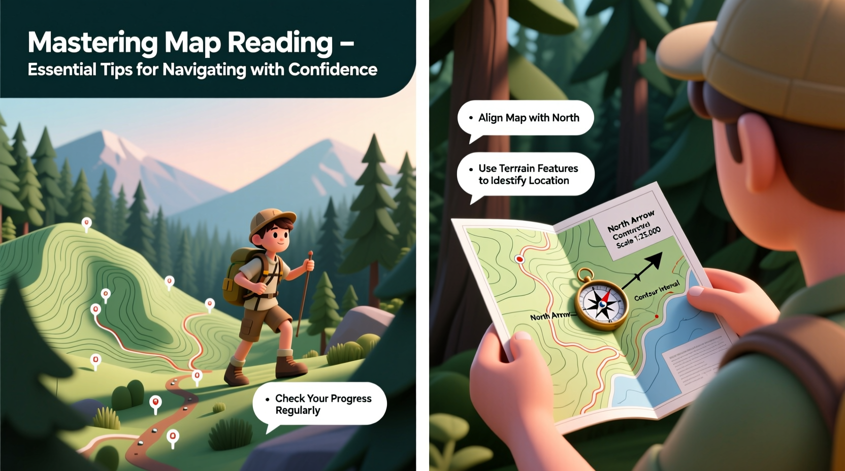
- Compass rose: Shows true north and magnetic north. Critical for aligning your map with a compass.
- Grid system: Many maps use UTM (Universal Transverse Mercator) or latitude/longitude for precise location referencing.
| Feature | Symbol Example | Meaning |
|---|---|---|
| Blue line | Solid or dashed | Stream or intermittent watercourse |
| Brown circle | Closed loop | Hilltop or summit |
| Green shading | Area fill | Dense vegetation or forest |
| Red line | Thick, solid | Major highway or primary road |
| Black X | Point symbol | Survey marker or triangulation point |
Use a Compass to Orient Your Map
Even the most detailed map is useless if you don’t know which way you’re facing. Combining a map with a baseplate compass allows accurate orientation and route planning.
To align your map:
- Place the map on a flat surface.
- Set your compass on the map so the edge runs parallel to the north-south grid lines.
- Rotate the map and compass together until the compass needle aligns with magnetic north (account for declination if necessary).
- Verify your position by identifying visible landmarks—peaks, rivers, or roads—that match the map.
Magnetic declination—the difference between true north and magnetic north—varies by location and changes over time. Ignoring it can lead to significant navigation errors. Most topographic maps list the current declination in the margin. Adjust your compass accordingly or mentally compensate when taking bearings.
“Map and compass skills are foundational. In over 30 years of search and rescue operations, I’ve seen too many people stranded because they trusted their phone instead of learning basics.” — Captain Luis Mendez, Mountain Rescue Team Lead
Plan and Follow a Route with Confidence
Navigating isn’t just about knowing where you are—it’s about moving purposefully toward your destination. Use this step-by-step approach:
- Identify start and end points. Mark them clearly on the map.
- Break the journey into segments. Use natural waypoints like ridgelines, stream junctions, or trail intersections.
- Check for obstacles. Steep slopes, dense forests, or private property may require detours.
- Take bearings. Use your compass to determine the azimuth (direction in degrees) to each waypoint.
- Measure distances. Use the map’s scale bar to estimate segment lengths and pace accordingly.
- Monitor progress. Frequently cross-reference your surroundings with the map to stay on track.
Mini Case Study: Lost on the Appalachian Trail
In 2022, a solo hiker in Virginia strayed from the Appalachian Trail during heavy fog. Her phone had died, and she couldn't recall the last landmark. Using a crumpled USGS map and a basic compass, she paused to reorient. She identified a nearby creek shown on the map and matched its bend pattern to her surroundings. By following the stream downstream—knowing it would eventually meet a service road—she reached safety within three hours. Rescuers later confirmed she was less than two miles off course. Her calm application of map reading saved time, energy, and risk.
Build Practical Skills: A Navigation Checklist
To become proficient, practice regularly. Use this checklist to guide your training:
- ✅ Learn to identify your current location using terrain association (matching what you see to the map)
- ✅ Practice taking and following compass bearings in open fields
- ✅ Simulate navigation in daylight before attempting night or poor-weather routes
- ✅ Memorize common map symbols and contour interval values
- ✅ Conduct a “map-only” walk in a familiar park to test orientation skills
- ✅ Teach someone else—explaining concepts reinforces your own understanding
Frequently Asked Questions
Can I rely solely on a GPS device?
While GPS is powerful, it has limitations: battery life, signal loss in canyons or dense forest, and potential malfunction. A map and compass are fail-safe backups. The best practice is to use GPS as a tool alongside traditional navigation, not a replacement.
How do I find my location if I’m completely lost?
Stop, stay calm, and assess. Identify prominent features—mountains, lakes, roads—and compare them to the map. Use triangulation with a compass and at least two visible landmarks to pinpoint your position. If no features are recognizable, stay put and conserve energy while signaling for help.
What’s the easiest way to learn map reading?
Start small. Choose a local park with a simple trail map. Walk the paths while constantly referencing the map, noting how turns, elevation changes, and landmarks appear. Gradually move to more complex terrain. Apps like Gaia GPS or ViewRanger allow side-by-side digital and paper map comparison for learning.
Conclusion: Navigate with Independence and Confidence
Mastering map reading is more than a survival skill—it’s a gateway to freedom in the outdoors. It empowers you to explore beyond marked trails, respond calmly in disorienting conditions, and trust your judgment over gadgets. In a world increasingly dependent on automation, the ability to read a map stands as a testament to human capability and resilience.
The knowledge won’t come overnight. But with consistent practice, thoughtful preparation, and respect for the terrain, anyone can develop the quiet confidence of a skilled navigator. Pick up a map this weekend, step outside, and start seeing the world through the eyes of those who truly know where they’re going.


 浙公网安备
33010002000092号
浙公网安备
33010002000092号 浙B2-20120091-4
Comments
No comments yet. Why don't you start the discussion?