
Navigating by the stars is one of humanity’s oldest skills, used by sailors, explorers, and indigenous cultures for millennia to traverse vast oceans and unmarked landscapes. While GPS dominates modern travel, mastering celestial navigation offers a profound connection to nature, enhances survival readiness, and builds confidence in remote environments. With clear skies and basic knowledge, anyone can learn to find their way using only the night sky. This guide provides actionable techniques, essential reference points, and real-world strategies to help you navigate confidently after dark.
Understanding the Celestial Sphere
The night sky behaves like a rotating dome centered on Earth. Stars appear to move from east to west due to planetary rotation, but their relative positions remain fixed over human timescales. This predictable motion makes them reliable navigational markers. The key is identifying stable reference points—particularly circumpolar stars that never set below the horizon in your hemisphere.
In the Northern Hemisphere, Polaris (the North Star) sits almost directly above the North Pole, making it the most crucial anchor for orientation. In the Southern Hemisphere, where Polaris is not visible, the Southern Cross (Crux) and its pointer stars serve as primary directional guides. Learning to locate these markers is the foundation of star navigation.
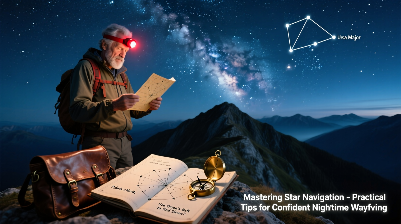
Locating Key Navigational Stars and Constellations
Finding your way starts with identifying major constellations. These patterns act as signposts leading to critical directional stars.
Finding Polaris in the Northern Hemisphere
Polaris lies at the end of the Little Dipper’s handle, but this constellation is often faint. A more reliable method uses the Big Dipper (part of Ursa Major), which rotates around Polaris throughout the year.
- Locate the Big Dipper—seven bright stars forming a ladle shape.
- Identify the two stars at the outer edge of the cup (Dubhe and Merak).
- Draw an imaginary line upward through these “pointer” stars.
- Extend that line about five times the distance between them; it leads directly to Polaris.
Once found, drop a vertical line from Polaris to the horizon—this marks true north. Unlike magnetic compasses, Polaris indicates geographic north, unaffected by local interference.
Using the Southern Cross in the Southern Hemisphere
Below the equator, the Southern Cross (Crux) is the primary tool for finding south. It consists of four bright stars forming a tilted cross.
- Identify the long axis of the cross, running from Gacrux to Acrux.
- Extend this line downward four and a half times its length.
- The point where it meets the horizon approximates south.
- For greater accuracy, use the \"Pointer Stars\" (Alpha and Beta Centauri) as a reference. Draw a perpendicular bisector between them—the intersection with the extended cross line confirms south.
“The stars don’t lie. They’ve guided Polynesian voyagers across thousands of miles of open ocean long before instruments existed.” — Dr. Te Hana Waipara, Cultural Astronomer
Practical Techniques for Nighttime Wayfinding
Knowing how to find north or south is only the beginning. Translating celestial cues into ground movement requires technique and awareness.
Step-by-Step Guide: Maintaining Direction Through the Night
- Establish Initial Bearing: Use Polaris or the Southern Cross to determine your starting direction.
- Select Ground Markers: Pick a distant landmark (tree, rock, hill) aligned with your celestial bearing. Walk toward it.
- Recheck Regularly: Every 5–10 minutes, glance back at the sky to ensure alignment hasn’t drifted.
- Use Multiple Reference Points: If clouds obscure key stars, rely on other constellations like Orion or Cassiopeia to maintain general orientation.
- Adjust for Star Movement: Remember that stars shift slowly. Reassess your bearing every 30 minutes if traveling long distances.
Essential Star Navigation Checklist
- ✅ Learn to identify the Big Dipper, Little Dipper, Orion, and Cassiopeia (Northern Hemisphere)
- ✅ Master locating Polaris using the pointer stars
- ✅ Study the Southern Cross and Alpha Centauri pair (Southern Hemisphere)
- ✅ Practice under clear skies away from light pollution
- ✅ Carry a star chart or app (for learning only—not reliance)
- ✅ Use terrain features to reinforce celestial bearings
- ✅ Track time to anticipate seasonal star positions
Common Challenges and How to Overcome Them
Star navigation isn’t flawless. Cloud cover, urban glow, and inexperience can hinder progress. Here’s how to adapt:
| Challenge | Solution |
|---|---|
| Cloudy or hazy skies | Rely on moon position, wind patterns, or terrain cues until visibility improves |
| Light pollution obscures stars | Focus on brightest stars (e.g., Sirius, Vega, Arcturus); move to darker areas if possible |
| Confusing similar star patterns | Memorize distinctive shapes: W-shape of Cassiopeia vs. bowl of Big Dipper |
| Losing sight of Polaris | Use Orion’s Belt—when vertical, it points roughly north-south |
| Seasonal star shifts | Learn monthly sky maps; note that Orion dominates winter skies, Scorpius appears in summer |
Real-World Example: Crossing Open Terrain at Night
A solo hiker in the Utah desert finishes a late summit descent just as dusk falls. With no trail markers and fading phone battery, she recalls her training in celestial navigation. Facing north, she spots the Big Dipper low in the northeast. Using Dubhe and Merak, she traces the line upward and locates Polaris. She picks a distant ridge aligned with that bearing and walks toward it. Every ten minutes, she stops, checks the sky, and selects a new landmark. By maintaining this rhythm, she reaches her campsite safely by midnight—guided entirely by the stars.
Advanced Tips for Greater Accuracy
For those seeking precision, deeper astronomical knowledge enhances reliability.
- Estimate Latitude Using Polaris: The angle between Polaris and the horizon equals your latitude. At the equator, Polaris sits on the horizon (0°). At the North Pole, it’s overhead (90°). Use your hand at arm’s length: a fist covers ~10 degrees, ideal for rough estimation.
- Track Time via Star Rotation: Stars move 15 degrees per hour. Watch a bright star’s position relative to a tree or peak to estimate elapsed time.
- Use Seasonal Guides: Winter skies feature Orion and Taurus; summer brings Sagittarius and Cygnus. Knowing what should be visible helps verify location.
FAQ
Can I navigate by stars near the equator?
Yes, but it’s more complex. Polaris appears near the northern horizon, and the Southern Cross rises in the south. You can use both systems depending on visibility. The celestial equator passes overhead, so stars rise and set more vertically, aiding directional cues.
How accurate is star navigation?
With practice, you can achieve within 1–3 degrees of true direction. Factors like observer skill, atmospheric clarity, and landmark selection affect precision. It’s less precise than GPS but highly reliable when tools fail.
Do I need special equipment?
No. Star navigation requires only your eyes and knowledge. A notebook for sketching star positions or a simple clinometer (to measure angles) can help, but they’re optional.
Maintaining Confidence Under Pressure
The greatest challenge in nighttime navigation isn’t technical—it’s psychological. Darkness amplifies uncertainty. To stay calm:
- Breathe steadily and move deliberately.
- Trust your training over panic.
- Pause frequently to reassess rather than rush forward.
- Speak directions aloud to reinforce focus.
Like any skill, confidence grows with repetition. Practice in safe environments—backyards, parks, familiar trails—before relying on it in remote areas.
Conclusion
Mastering star navigation transforms the night from an obstacle into a guide. It reconnects us with ancient wisdom and equips us to move confidently through the world, even when technology fails. Whether you're a backpacker, sailor, or outdoor enthusiast, the ability to read the sky is a timeless asset. Start tonight: step outside, find the Big Dipper or Southern Cross, and take your first bearing. With patience and practice, the stars will always show you the way.


 浙公网安备
33010002000092号
浙公网安备
33010002000092号 浙B2-20120091-4
Comments
No comments yet. Why don't you start the discussion?