
Gravity is often thought of as a constant force—what pulls us down, keeps planets in orbit, and gives weight to objects. But what if you were told that gravity isn’t the same everywhere on Earth? That in some places, you’d technically weigh slightly more or less than in others? It sounds like science fiction, but it’s a well-documented scientific reality. And despite this variation, scientists are able to produce detailed gravity maps that help us understand Earth’s structure, monitor water resources, and even predict geological hazards. So how does that work?
Why Gravity Isn’t Uniform Across Earth
The strength of gravity at any point on Earth depends on several factors: altitude, latitude, local geology, and even the distribution of mass deep beneath the surface. While Newton’s law of universal gravitation tells us that every mass attracts every other mass, the real-world application on a rotating, layered, and irregularly shaped planet like Earth introduces complexity.
For instance, gravity is weaker at the equator than at the poles for two main reasons. First, Earth bulges at the equator due to its rotation, meaning points on the equator are farther from the planet’s center—increasing distance weakens gravitational pull. Second, the centrifugal force caused by Earth’s spin counteracts gravity slightly at the equator, further reducing effective gravity.
Beyond these global variations, local differences arise from the density of materials below the surface. A mountain range made of dense rock exerts a stronger gravitational pull than a sediment-filled basin. Similarly, underground aquifers, oil reservoirs, or magma chambers can subtly alter the local gravitational field.
“Gravity mapping allows us to ‘see’ beneath the surface without drilling. It’s like an X-ray for the Earth.” — Dr. Sarah Chen, Geophysicist at NASA’s Goddard Space Flight Center
How Scientists Measure Tiny Differences in Gravity
To map these minute variations, scientists rely on instruments far more sensitive than traditional scales. Ground-based gravimeters can detect changes in gravity as small as one part in a billion. These devices use highly calibrated springs or supercooled atoms in quantum sensors to measure acceleration due to gravity with extreme precision.
However, ground measurements are limited in scope. To get a full picture of Earth’s gravity field, we need space-based observations. This is where satellite missions come into play—specifically, projects like GRACE (Gravity Recovery and Climate Experiment) and its successor, GRACE-FO (Follow-On).
The Role of Satellite Missions: GRACE and GRACE-FO
Launched in 2002 and 2018 respectively, the GRACE missions consist of two identical satellites flying in tandem about 220 kilometers apart in low-Earth orbit. As they pass over areas with stronger or weaker gravity, the leading satellite speeds up or slows down slightly, changing the distance between the two. Microwaves are used to measure this gap with accuracy down to a fraction of the width of a human hair.
These tiny changes in separation are translated into detailed maps of Earth’s gravity field. Over time, comparing these maps reveals how mass is redistributed across the planet—such as melting ice sheets, shifting groundwater, or post-glacial rebound (where land slowly rises after being freed from heavy ice sheets).
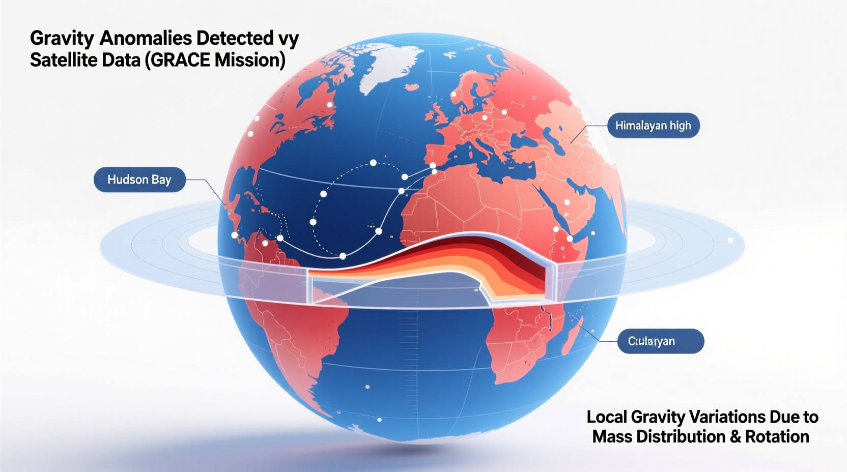
Understanding Gravity Maps: What the Colors Mean
Gravity maps are typically color-coded visualizations showing deviations from Earth’s average gravity field. These are called “gravity anomalies.” Blue areas represent regions where gravity is weaker than average; red areas indicate stronger-than-average gravity.
For example, parts of southern India and Hudson Bay in Canada show negative gravity anomalies. In Hudson Bay’s case, this is largely due to post-glacial rebound—the land is still rising after the last ice age, so there’s less mass beneath the surface now than before. Meanwhile, the Himalayas and Andes appear as high-gravity zones because of their massive, dense rock formations.
It’s important to note that gravity maps don’t show raw gravity values. Instead, they display deviations after removing the effects of Earth’s shape and rotation. This isolates the influence of subsurface mass variations, making them useful for geophysical interpretation.
Key Applications of Gravity Mapping
- Climate Science: Tracking changes in ice sheet mass and groundwater storage.
- Geology: Identifying fault lines, mineral deposits, and subsurface structures.
- Oceanography: Improving models of ocean circulation by understanding seafloor topography.
- Hydrology: Monitoring droughts and aquifer depletion over time.
- Natural Hazards: Assessing risks related to volcanic activity or landslides.
Step-by-Step: How a Gravity Map Is Created
- Data Collection: Satellites like GRACE-FO continuously measure the distance between twin probes using microwave ranging.
- Orbit Modeling: Scientists calculate expected satellite paths based on known forces like atmospheric drag and solar radiation.
- Anomaly Detection: Deviations from predicted orbits are attributed to gravitational variations.
- Mass Inversion: Using mathematical models, researchers convert gravity data into estimates of mass change (e.g., water equivalent thickness).
- Visualization: Data is processed into global maps updated monthly, showing trends over time.
Mini Case Study: Tracking Drought in California
Between 2011 and 2017, California experienced one of its worst droughts on record. Traditional methods struggled to quantify how much groundwater was being lost. However, GRACE data revealed a dramatic decline in underground water storage—over 16 cubic kilometers per year during peak drought years.
This information was crucial for policymakers managing water rights and agricultural usage. By identifying regions with the fastest aquifer depletion, authorities could prioritize conservation efforts and adjust pumping regulations. The gravity data provided objective, large-scale evidence that helped guide sustainable water management decisions.
Common Misconceptions About Gravity Maps
| Misconception | Reality |
|---|---|
| Gravity maps show elevation. | No—they show mass distribution, which may or may not correlate with topography. |
| Stronger gravity always means mountains. | Not necessarily—dense minerals underground can increase gravity without surface features. |
| Gravity changes are noticeable to humans. | Variations are extremely small—less than 0.5% difference across Earth. |
| Satellites measure gravity directly. | They infer gravity from orbital perturbations and precise distance measurements. |
Frequently Asked Questions
Can gravity be zero somewhere on Earth?
No. While gravity varies, it never reaches zero on or near Earth’s surface. Even in microgravity environments like orbit, gravity is still about 90% of surface strength—it’s the continuous freefall that creates the sensation of weightlessness.
Do gravity maps help find oil or minerals?
Yes. Exploration companies use high-resolution gravity surveys to identify subsurface structures that may contain oil, gas, or valuable ores. Anomalies can indicate salt domes, basins, or dense metallic deposits.
How often are global gravity maps updated?
GRACE-FO provides new gravity field models approximately every 30 days. However, due to noise and short-term fluctuations, scientists often analyze data averaged over several months to identify meaningful trends.
Checklist: What You Should Know About Gravity Variability
- Gravity differs slightly depending on location due to Earth’s shape and internal composition.
- Satellite missions like GRACE-FO track changes in Earth’s gravity field over time.
- Gravity maps reveal hidden processes such as groundwater loss and ice melt.
- These maps are essential tools in climate science, geology, and resource management.
- The data is publicly available and used by researchers worldwide.
Conclusion: Seeing the Invisible Forces That Shape Our Planet
Gravity may feel like a constant in daily life, but its subtle variations tell powerful stories about our planet’s inner workings. From tracking vanishing glaciers to uncovering ancient geological structures, gravity maps turn invisible forces into actionable insights. They remind us that Earth is a dynamic system, constantly reshaping itself beneath our feet.


 浙公网安备
33010002000092号
浙公网安备
33010002000092号 浙B2-20120091-4
Comments
No comments yet. Why don't you start the discussion?