
Anyone who has looked up at a stormy sky has likely noticed the dramatic shift in cloud color—from soft white puffs to deep, ominous gray or even black. But why do rain clouds appear so dark? The answer lies in atmospheric physics, light behavior, and the structure of clouds themselves. Understanding this phenomenon not only satisfies curiosity but also helps us interpret weather patterns more accurately.
The Science Behind Cloud Color
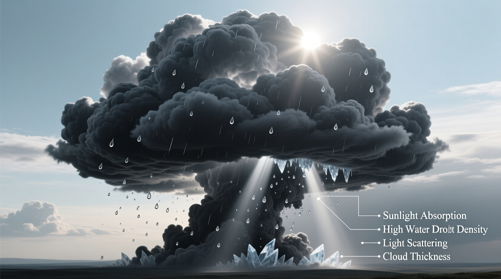
Clouds are made of tiny water droplets or ice crystals suspended in the atmosphere. When sunlight hits these particles, it scatters in all directions. For thin or small clouds, most of the sunlight is scattered back into the atmosphere and reaches our eyes, making them appear bright white. This is due to Mie scattering—where light waves interact with particles similar in size to their wavelength, scattering all colors equally.
However, as clouds grow thicker and denser—especially those associated with storms—the amount of light that can pass through diminishes significantly. The top layers of the cloud reflect sunlight, but the lower sections absorb and scatter much of the incoming light. With less light penetrating to the base, the cloud appears increasingly gray or dark from below.
How Cloud Thickness Affects Darkness
The key factor in determining a cloud’s darkness is its vertical depth. Cumulonimbus and nimbostratus clouds, which produce rain, can extend thousands of feet into the atmosphere. A typical fair-weather cumulus cloud might be 2,000 to 3,000 feet thick, while a mature thunderstorm cloud can exceed 40,000 feet.
In such massive formations, sunlight must travel through hundreds or even thousands of layers of water droplets. Each interaction reduces the intensity of the light. By the time any light reaches the bottom of the cloud, very little remains to be reflected downward. This creates the visual effect of a dark underbelly.
Moreover, when the sun is low on the horizon (during sunrise or sunset), the angle of light can accentuate the contrast between illuminated cloud tops and shadowed bases, enhancing the perception of darkness.
Light Absorption vs. Scattering: What’s Really Happening?
It's a common misconception that dark clouds are \"full of rain\" in a way that inherently makes them black. In reality, the darkness is not caused by the presence of water itself, but by the reduction of visible light reaching our eyes.
- Thin clouds allow most sunlight to pass through or scatter back—appearing white or light gray.
- Thick clouds block and absorb significant portions of sunlight, especially at the base where multiple layers accumulate.
- Overcast skies occur when a continuous layer of thick clouds blankets the sky, diffusing and weakening sunlight across a wide area.
The process is similar to holding a piece of paper up to a lamp. A single sheet is translucent and glows brightly. Stack ten sheets, and very little light gets through. Clouds work the same way—more droplets mean less transmitted light.
“Cloud color is one of the most reliable visual indicators of its internal density and potential for precipitation.” — Dr. Lena Peterson, Atmospheric Scientist, NOAA
Do Dark Clouds Always Mean Rain?
While dark clouds often signal impending rain, they don’t guarantee it. Several factors influence whether precipitation actually reaches the ground:
- Cloud depth and moisture content: Thicker clouds with high liquid water content are more likely to produce rain.
- Updraft strength: Strong upward air currents keep droplets suspended, delaying rainfall.
- Evaporation below cloud base: In dry environments, rain may evaporate before hitting the ground—a phenomenon known as virga.
Additionally, some clouds appear dark simply due to shadowing. A tall cumulus cloud may cast a shadow on a neighboring cloud, making it look darker even if it isn’t producing rain.
Real-World Example: The Surprise Storm
Consider a hiker in the Rockies who notices a large cloud building in the afternoon. At first, it looks like a normal summer puff. Within an hour, the base turns slate gray. The hiker recalls that morning’s forecast mentioned isolated thunderstorms but didn’t expect one so soon. Minutes after noticing the darkening sky, heavy rain begins.
This scenario illustrates how observing cloud color changes can serve as a practical, real-time weather warning system—especially in remote areas without access to radar or alerts.
Comparing Cloud Types and Their Colors
| Cloud Type | Typical Color | Rain Potential | Notes |
|---|---|---|---|
| Cirrus | White, wispy | None | High-altitude ice crystals; often indicate changing weather |
| Cumulus | Bright white | Low | Fair-weather clouds; fluffy with flat bases |
| Stratocumulus | Gray to light white | Light drizzle possible | Layered, lumpy appearance; cover large sky areas |
| Nimbostratus | Dark gray | Moderate, steady rain | Thick, featureless layers; often overcast |
| Cumulonimbus | Very dark base, bright top | Heavy rain, thunderstorms | Towering clouds; anvil-shaped tops; may produce hail |
Common Misconceptions About Dark Clouds
Several myths persist about dark rain clouds. Addressing them improves both scientific literacy and safety during severe weather.
- Myth: Dark clouds are heavier because they’re full of water.
Reality: While rain clouds contain more water, their perceived \"heaviness\" is visual, not gravitational. Air buoyancy supports the droplets. - Myth: Black clouds mean tornadoes are coming.
Reality: While cumulonimbus clouds can spawn tornadoes, darkness alone doesn’t predict them. Rotation and structural features matter more. - Myth: If it’s not raining yet, the dark cloud isn’t dangerous.
Reality: Lightning can strike miles ahead of rainfall. A dark cloud means electrical activity is possible.
How to Use Cloud Observation in Daily Life
Learning to read cloud color and structure enhances situational awareness. Whether you're planning a picnic, a flight, or outdoor photography, here’s a simple checklist to assess rain likelihood:
- ✅ Is the cloud growing vertically? (Sign of instability)
- ✅ Is the base uniformly dark and lowering? (Indicates thick moisture)
- ✅ Are other clouds converging toward it? (Suggests active weather system)
- ✅ Can you feel a drop in temperature or shift in wind? (Front approaching)
- ✅ Is there distant thunder or flashes of light? (Confirmed storm activity)
Frequently Asked Questions
Why do some rain clouds look green?
Greenish clouds are rare but often reported before severe thunderstorms or tornadoes. One theory suggests that sunlight filtering through dense, water-laden clouds interacts with red twilight hues, creating a green tint. Another proposes that hail within the cloud scatters blue light, which mixes with red ambient light to produce green. While not a definitive predictor, green clouds warrant caution.
Can clouds be too thick to rain?
No—but sometimes they delay rain. Extremely thick clouds with strong updrafts can suspend water droplets for extended periods. Eventually, droplets coalesce and fall when gravity overcomes lift. However, in highly turbulent storms, rain may come in intense bursts rather than steady showers.
Why do clouds turn gray at night?
At night, clouds reflect artificial light from cities or moonlight. Without direct sunlight, their color depends on available illumination. Over urban areas, they may appear dull orange or gray; under a full moon, they can seem silvery. Rain-bearing clouds still appear darker due to their density blocking background light.
Final Thoughts: Seeing Weather Clearly
The next time you glance up at a dark sky, remember: the color of a cloud is not magic, but physics in action. It reveals the interplay between sunlight, water, and atmospheric structure. Recognizing why rain clouds darken empowers you to make smarter decisions—whether it’s grabbing an umbrella, postponing a flight, or simply appreciating the complexity of nature’s designs.


 浙公网安备
33010002000092号
浙公网安备
33010002000092号 浙B2-20120091-4
Comments
No comments yet. Why don't you start the discussion?