
Clouds are among the most visible and dynamic features of our atmosphere, yet their shifting colors often go unnoticed beyond casual observation. Most people associate white fluffy clouds with fair weather and dark grey ones with storms. But what causes this transformation? Why do rain clouds appear grey when other clouds shine bright white? The answer lies in a combination of physics, atmospheric optics, and meteorology — all working together to shape how sunlight interacts with water droplets and ice crystals suspended high above us.
Understanding why rain clouds turn grey not only satisfies curiosity but also enhances our ability to interpret weather patterns simply by looking up. This phenomenon is rooted in how light behaves when it encounters dense accumulations of moisture, and it reveals much about the internal structure and development stage of a cloud.
The Basics of Cloud Formation and Color
Clouds form when warm, moist air rises and cools, causing water vapor to condense around tiny particles like dust or salt in the atmosphere. These microscopic droplets cluster together, forming visible masses we recognize as clouds. In their early stages, these formations typically appear white because they are composed of small droplets that efficiently scatter sunlight in all directions — a process known as Mie scattering.
Sunlight, though perceived as white, contains the full spectrum of visible colors. When it hits a thin or moderately thick cloud, most of the light is scattered uniformly across wavelengths, preserving the white appearance. However, as clouds grow vertically and horizontally — especially those capable of producing rain — their optical properties change dramatically.
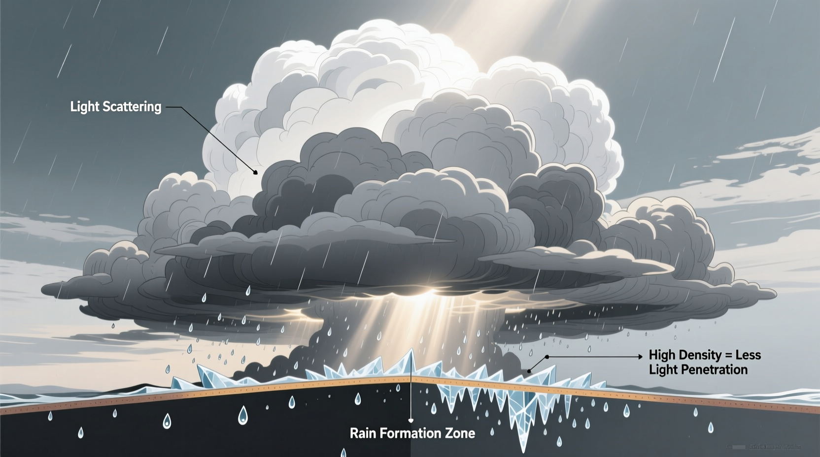
How Light Interaction Changes with Cloud Density
The key factor behind the greying of rain clouds is density. As a cloud develops into a rain-bearing system — such as a cumulonimbus or nimbostratus — it accumulates vast quantities of water droplets and ice particles. This increased concentration means more sunlight is absorbed and scattered within the cloud rather than reflected back to an observer on the ground.
In scientific terms, this is governed by the principle of multiple scattering. While individual droplets still scatter all wavelengths of light, the sheer number of interactions inside a dense cloud prevents much of the light from escaping downward. Instead, photons bounce repeatedly between droplets, losing energy and direction until they are either absorbed or redirected upward and out the top of the cloud.
From the ground, this results in a diminished amount of light reaching your eyes from the base of the cloud — hence the perception of grey or even black under extreme conditions. It’s not that the cloud itself is inherently grey; it’s that very little light is making it through.
Factors Influencing Rain Cloud Darkness
| Factor | Effect on Cloud Color | Scientific Explanation |
|---|---|---|
| Cloud Thickness | Thicker = Darker | More water mass absorbs and scatters light before it can pass through. |
| Droplet Concentration | Higher = Less Transmittance | Denser packing reduces space for light to travel unimpeded. |
| Time of Day | Late afternoon/evening enhances grey tone | Lower sun angle reduces overall illumination intensity. |
| Background Sky Brightness | Contrast effect | Bright surrounding sky makes dense clouds look comparatively darker. |
Why Some Grey Clouds Don’t Produce Rain
Not every grey cloud brings precipitation. The presence of grey tones indicates significant opacity, but not necessarily active rainfall. For example, altostratus clouds may appear uniformly grey and block sunlight without producing heavy rain. Their water content might be insufficient or too evenly distributed to allow droplet coalescence into larger drops that fall as rain.
In contrast, true rain clouds like nimbostratus or mature cumulonimbus exhibit both deep vertical development and high liquid water content. These systems often appear not just grey, but charcoal-like beneath, signaling strong updrafts, ice formation, and ongoing precipitation processes.
“Cloud color is one of the simplest visual indicators of its internal dynamics. A darkening base often precedes rainfall by minutes — nature’s way of giving us a heads-up.” — Dr. Lena Patel, Atmospheric Scientist at the National Weather Center
Step-by-Step: How a Cloud Turns Grey Before Raining
- Moisture Accumulation: Warm, humid air rises due to convection or frontal lifting, increasing moisture levels in a localized area.
- Condensation Begins: Water vapor condenses on aerosols, forming tiny droplets that become visible as a white cloud.
- Vertical Growth: Continued uplift strengthens the cloud, allowing it to grow taller and denser over time.
- Increased Droplet Density: More droplets form and pack closely together, enhancing internal scattering and absorption of light.
- Reduced Light Transmission: Sunlight struggles to penetrate the thick layer, especially near the base where droplets are largest.
- Grey Appearance Emerges: From the ground, the cloud appears progressively darker as less light reaches the observer.
- Precipitation Initiates: Once droplets coalesce into raindrops large enough to overcome updrafts, rain begins to fall.
Real-World Observation: A Commuter’s Experience
Jamal, a bike commuter in Seattle, relies on quick sky assessments to decide whether to carry his rain jacket. One morning, he noticed the usual patchy stratus layer beginning to merge into a uniform sheet overhead. By midday, the once-bright cloud cover had turned slate grey. “I’ve learned that when the whole sky goes flat and dark,” he says, “it’s not just overcast — it’s loading up.” He turned back to grab his gear just before steady rain began ten minutes later. His experience reflects a practical application of interpreting cloud color changes as predictive cues.
Frequently Asked Questions
Can rain clouds ever be colors other than grey?
Yes. During sunrise or sunset, rain clouds can appear red, orange, or pink due to the scattering of long-wavelength light through the lower atmosphere. The cloud remains physically grey, but it reflects the ambient colored light. Similarly, lightning-lit clouds at night may briefly glow purple or blue.
Do all grey clouds produce rain?
No. While grey coloration suggests high opacity and potential for precipitation, some grey clouds lack the vertical motion or moisture depth needed for rain. Stratocumulus or thick fog banks can appear dark without yielding any measurable rainfall.
Why do some storm clouds look green before severe weather?
A rare greenish tint in thunderstorms is believed to result from sunlight filtering through extremely dense, water-rich clouds combined with reddened light from a low sun (often late afternoon). This phenomenon is sometimes associated with hail-producing supercells, though not all green clouds bring severe weather.
Maintaining Awareness Through Observation
- Monitor gradual darkening of cloud bases as a sign of increasing moisture load.
- Compare the brightness of different cloud layers; layered greys suggest stability, while sharply defined dark bases indicate active development.
- Use shadows cast by clouds to gauge thickness — deeper shadows mean denser structures.
- Avoid assuming all dark clouds are dangerous; context matters based on season, location, and sky coverage.
Conclusion
The greyness of rain clouds is far more than a mere aesthetic shift — it’s a direct consequence of physical processes governing light and matter in the atmosphere. By absorbing and scattering sunlight, thick, moisture-laden clouds signal their readiness to release precipitation long before the first drop falls. Recognizing this visual cue empowers anyone, from farmers to hikers to casual observers, to make informed decisions based on real-time environmental signals.


 浙公网安备
33010002000092号
浙公网安备
33010002000092号 浙B2-20120091-4
Comments
No comments yet. Why don't you start the discussion?