
Weather forecasts have become an essential part of daily life—guiding everything from commute decisions to agricultural planning. Yet despite decades of scientific advancement, forecasts still occasionally miss the mark. A sunny prediction might turn into a downpour; a storm could veer off course with little warning. While modern meteorology is more accurate than ever, inaccuracies persist due to the complex, dynamic nature of Earth’s atmosphere. Understanding why forecasts go wrong isn’t about discrediting science—it’s about appreciating the challenges behind predicting one of nature’s most chaotic systems.
The Butterfly Effect: Chaos in the Atmosphere
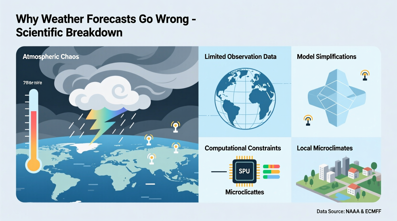
The foundation of weather forecasting lies in physics and mathematics, but even the most sophisticated models must contend with chaos theory. In the 1960s, meteorologist Edward Lorenz discovered that tiny changes in initial atmospheric conditions could lead to vastly different outcomes—a phenomenon popularly known as the \"butterfly effect.\" This means that if temperature, humidity, or wind speed measurements are off by even a fraction, the forecast can diverge significantly over time.
Because the atmosphere is a nonlinear system, small errors amplify rapidly. For example, a misplaced high-pressure system in a model today might result in an incorrect rainfall estimate three days later. This sensitivity limits the useful range of detailed forecasts to about 7–10 days, beyond which predictions become increasingly speculative.
“Small uncertainties in the initial state of the atmosphere grow exponentially, making long-range precision inherently limited.” — Dr. Kerry Emanuel, Atmospheric Scientist, MIT
Data Gaps and Observation Limitations
Accurate forecasting depends on comprehensive data collection. Meteorologists rely on satellites, weather balloons, ground stations, radar, and ocean buoys to monitor atmospheric conditions globally. However, coverage is far from uniform.
Oceans, polar regions, and developing nations often lack sufficient monitoring infrastructure. Over the Pacific Ocean, for instance, there are vast stretches where real-time data is sparse. When models initialize without complete observational input, they must interpolate or estimate missing values—introducing potential error.
Satellites provide broad coverage but may not capture fine-scale details such as localized convection or microclimates in mountainous terrain. Similarly, urban heat islands or coastal breezes can develop too quickly for current observation networks to fully resolve.
Limitations of Forecast Models
Numerical weather prediction (NWP) models are the engines behind modern forecasts. These computer simulations solve complex equations representing atmospheric dynamics. But no model is perfect. Each uses approximations to represent physical processes like cloud formation, radiation, and turbulence—collectively called \"parameterizations.\"
Different models—such as the Global Forecast System (GFS) used by the U.S., the European Centre for Medium-Range Weather Forecasts (ECMWF), and the UK Met Office model—can produce divergent results due to variations in resolution, algorithms, and how they handle data assimilation.
Model resolution is especially critical. High-resolution models capture finer details, such as thunderstorm development or valley winds, but require immense computing power. Lower-resolution models may smooth out these features, leading to missed or misplaced precipitation.
| Model | Region | Strengths | Common Shortcomings |
|---|---|---|---|
| ECMWF | Global | High accuracy in medium-range forecasts | Limited public access; slower updates |
| GFS | Global | Frequent updates; open data access | Less precise in storm track prediction |
| HRRR | U.S. (high-res) | Hourly updates; excellent for short-term storms | Short lead time; less reliable beyond 18 hours |
Human Interpretation and Communication Challenges
Even with advanced models, human meteorologists play a vital role in interpreting output and communicating risk. A model may suggest a 60% chance of rain, but conveying what that means to the public is nuanced. Does it mean rain for 60% of the area? Or a 60% likelihood at a single location?
Miscommunication can make forecasts seem inaccurate when they were probabilistically correct. Additionally, media outlets sometimes simplify forecasts for brevity, omitting uncertainty ranges or confidence levels. Viewers remember the “missed storm” more vividly than the many accurate predictions, reinforcing skepticism.
Forecasters also face pressure to avoid under-warning. If a severe storm is possible but uncertain, issuing a watch or warning may lead to “crying wolf” if the event doesn’t materialize. Conversely, failing to warn could have dire consequences. This balancing act influences how forecasts are presented—even when the underlying science is sound.
Mini Case Study: The 2015 New York Snowstorm Forecast Error
In January 2015, New York City braced for a historic blizzard predicted to dump up to 30 inches of snow. Schools closed, transit halted, and emergency crews mobilized. But the storm weakened unexpectedly just before landfall, leaving most areas with less than 10 inches. The city faced criticism for overreacting.
Post-analysis revealed that subtle differences in the jet stream’s position caused the storm to intensify farther offshore than models anticipated. Initial runs of the GFS and ECMWF showed strong consensus on a major hit, but rapid changes in upper-level dynamics weren’t fully captured until too late. The case highlighted both model limitations and the difficulty of decision-making under uncertainty.
Improving Accuracy: What’s Being Done
Scientists and agencies are continuously working to reduce forecast errors. Key advancements include:
- Higher-resolution models: Supercomputers now run convection-permitting models that simulate individual storms without relying on coarse parameterizations.
- Better data assimilation: Techniques like ensemble forecasting combine multiple model runs with slightly varied starting points to quantify uncertainty.
- Expanded observation networks: CubeSats, drones, and crowdsourced weather station data (e.g., personal weather stations) are filling traditional gaps.
- Artificial intelligence: Machine learning models are being trained to detect patterns in historical forecast errors and adjust real-time predictions.
“We’re not trying to eliminate uncertainty—we’re trying to understand and communicate it better.” — Dr. Cliff Mass, Professor of Atmospheric Sciences, University of Washington
Checklist: How to Use Weather Forecasts More Effectively
- Check forecasts daily, especially during transitional seasons or active weather periods.
- Look beyond the main graphic—read discussion sections from trusted sources like the National Weather Service.
- Understand probability: A 40% chance of rain means scattered showers are possible, not that it will rain 40% of the day.
- Monitor trends across multiple models rather than relying on a single source.
- Pay attention to timing—forecasts often get the general idea right but misjudge exact onset or duration.
Frequently Asked Questions
Why do forecasts change so much from day to day?
As new observational data becomes available, models update their initial conditions. Small adjustments early in the forecast period can lead to large shifts in predicted outcomes, especially beyond 3–5 days. This doesn’t mean the forecast is “wrong”—it reflects improved understanding as the event nears.
Are long-range forecasts (e.g., 10-day) useless?
Not entirely. While specific details like daily highs or rain timing become unreliable after about seven days, broad patterns—such as whether a week will be warmer or cooler than average—are often skillful. Think of long-range forecasts as trend indicators, not precise plans.
Can climate change affect forecast accuracy?
Indirectly, yes. As global temperatures rise, weather patterns shift, and extreme events become more frequent and intense. Many forecasting models were calibrated on historical data from a more stable climate, making it harder to predict unprecedented conditions, such as record-breaking heat domes or rapid hurricane intensification.
Conclusion: Embracing Uncertainty for Better Decisions
Weather forecasts will never be 100% accurate—and that’s okay. The goal isn’t perfection but informed preparedness. By understanding the factors that limit accuracy, we can use forecasts more wisely: recognizing confidence levels, preparing for contingencies, and avoiding overreaction to worst-case scenarios.
Meteorology has made extraordinary progress. Today’s five-day forecast is as accurate as a three-day forecast was in the 1980s. With continued investment in technology, data, and public education, reliability will keep improving. In the meantime, staying weather-aware, checking updates regularly, and respecting the inherent unpredictability of nature are the best tools anyone can have.


 浙公网安备
33010002000092号
浙公网安备
33010002000092号 浙B2-20120091-4
Comments
No comments yet. Why don't you start the discussion?