
Tornadoes are among nature’s most violent phenomena, capable of causing widespread destruction within seconds. Despite their terrifying power, tornadoes follow a precise set of atmospheric conditions that allow them to form. Understanding why tornadoes occur involves examining complex interactions between temperature, moisture, wind patterns, and storm dynamics. This article breaks down the science behind tornado formation, identifies key ingredients, and explains the lifecycle of these destructive vortices.
The Essential Ingredients for Tornado Formation
Not every thunderstorm produces a tornado. Specific atmospheric conditions must align for a tornado to develop. Meteorologists identify four primary ingredients: moisture, instability, lift, and wind shear. When these elements converge in the right proportions, the stage is set for severe storms—and potentially, tornadoes.
- Moisture: Warm, moist air near the surface—typically drawn from the Gulf of Mexico in the U.S.—provides fuel for thunderstorms.
- Instability: When warm air near the ground is overlain by cooler, drier air aloft, it creates buoyancy. This unstable air rises rapidly, forming strong updrafts.
- Lift: A triggering mechanism such as a cold front, dryline, or terrain feature forces the warm, moist air upward, initiating thunderstorm development.
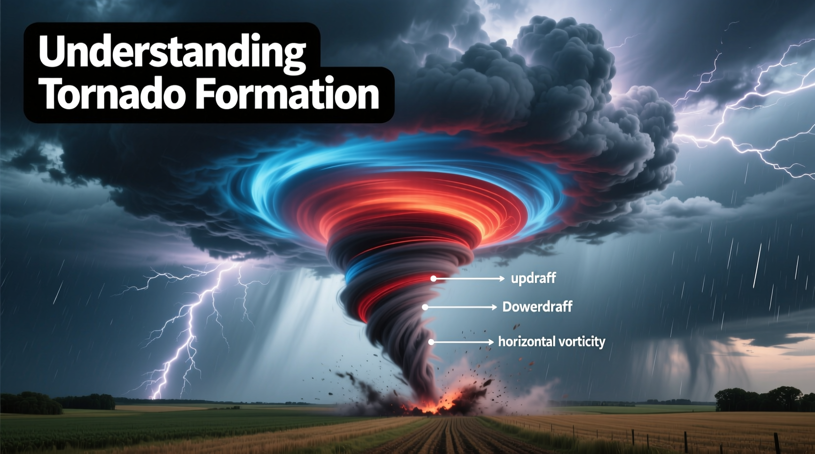
- Wind Shear: Changes in wind speed and direction with height create horizontal rotation in the lower atmosphere. This rotation is critical for tornado genesis.
From Thunderstorm to Tornado: The Role of Supercells
Most strong and violent tornadoes originate from a specific type of thunderstorm known as a supercell. Unlike ordinary thunderstorms, supercells are highly organized, long-lived systems characterized by a deep, rotating updraft called a mesocyclone.
Here's how a supercell evolves into a tornado-producing machine:
- A strong updraft develops due to instability and moisture.
- Wind shear causes horizontal spinning tubes of air in the lower atmosphere.
- The updraft tilts this horizontal rotation vertically, creating a rotating column of air—the mesocyclone.
- If the rotation intensifies and stretches toward the ground, a funnel cloud may descend.
- Once the funnel makes contact with the Earth’s surface, it becomes a tornado.
This process can take minutes to hours, and not all supercells produce tornadoes. However, when environmental conditions are optimal, the likelihood increases significantly.
“Supercell thunderstorms are the only storm type capable of producing long-track, violent tornadoes. Their rotating updraft is the engine that drives tornadogenesis.” — Dr. Harold Brooks, Senior Scientist at NOAA’s National Severe Storms Laboratory
Stages of Tornado Development
Tornadoes typically progress through five distinct stages, each visible through radar and visual observation:
| Stage | Description |
|---|---|
| Dust Whirl Stage | A small dust swirl forms on the ground beneath a rotating wall cloud. No funnel is visible yet. |
| Organizing Stage | A funnel cloud descends from the storm base. Rotation tightens and becomes more defined. |
| Mature Stage | The tornado reaches peak intensity and width. It is fully in contact with both the cloud base and the ground, causing maximum damage. |
| Shrinking Stage | The funnel narrows and begins to tilt. Wind speeds may still be high, but the vortex weakens. |
| Decay Stage | The tornado takes on a ropelike appearance before dissipating completely. |
The mature stage usually lasts between 5 and 20 minutes, though some violent tornadoes persist much longer. Duration and intensity depend on the strength of the parent storm and environmental support.
Why Some Areas Experience More Tornadoes
The central United States, particularly the region known as “Tornado Alley,” sees the highest frequency of tornadoes globally. This includes parts of Texas, Oklahoma, Kansas, Nebraska, and South Dakota. The reason lies in geography and climatology.
During spring and early summer, warm, moist air from the Gulf of Mexico flows northward, while dry air from the Rockies moves eastward. Cold air from Canada advances southward. Where these air masses collide—especially along drylines—intense thunderstorms and tornadoes frequently develop.
In recent years, research has shown a shift in tornado activity toward the southeastern U.S., an area sometimes referred to as “Dixie Alley.” Here, tornadoes often form at night, in hilly terrain, and within high-humidity environments, making them harder to spot and more deadly.
Mini Case Study: The 2011 Super Outbreak
In late April 2011, one of the largest tornado outbreaks in recorded history struck the southeastern United States. Over four days, 362 confirmed tornadoes touched down across 21 states, including 21 EF4 and EF5 tornadoes.
The event was fueled by an unusually strong upper-level low-pressure system that pulled deep moisture from the Gulf into the Southeast. Extreme wind shear, high instability, and multiple lifting mechanisms created perfect conditions for violent supercells.
One of the deadliest tornadoes was the Tuscaloosa–Birmingham EF4, which carved a 80-mile path and killed 64 people. Forecasters had issued warnings up to 20 minutes in advance—demonstrating improved prediction capabilities—but the scale and speed of the outbreak overwhelmed emergency response systems.
This case highlights how rare but powerful alignments of atmospheric conditions can lead to catastrophic outcomes, even with modern forecasting tools.
Step-by-Step: How Meteorologists Predict Tornadoes
Predicting tornadoes involves monitoring real-time data and identifying environments conducive to tornadogenesis. Here’s how experts assess risk:
- Analyze Surface Maps: Identify boundaries like drylines, cold fronts, or outflow boundaries where storms may initiate.
- Review Upper-Air Soundings: Examine balloon-launched radiosonde data to assess instability (CAPE values) and wind shear profiles.
- Monitor Radar Signatures: Look for hook echoes, velocity couplets (indicating rotation), and debris balls on Doppler radar.
- Watch for Wall Clouds and Funnel Clouds: Visual confirmation from spotters helps verify developing tornadoes.
- Issue Warnings: When rotation is detected and a tornado is imminent or occurring, the National Weather Service issues a Tornado Warning.
While forecasts can predict general risk areas days in advance, pinpointing exact tornado touchdowns remains challenging due to the small scale and rapid evolution of these events.
Frequently Asked Questions
Can tornadoes form without a visible funnel?
Yes. A tornado is defined by its rotating winds touching the ground, not by a visible funnel. Some tornadoes remain invisible until debris is lifted, revealing the vortex.
Do tornadoes only happen in the U.S.?
No, tornadoes occur worldwide, but the U.S. experiences the most due to its unique geography. Other countries with frequent tornadoes include Canada, Bangladesh, Argentina, and parts of Europe.
How fast do tornado winds travel?
Wind speeds vary widely. EF0 tornadoes have gusts of 65–85 mph, while EF5 tornadoes exceed 200 mph. The strongest tornado winds rival those of hurricanes but are far more concentrated.
Checklist: Preparing for Tornado Season
- Know your local warning system (sirens, apps, weather radio).
- Identify a safe shelter location (basement, interior room on the lowest floor).
- Assemble an emergency kit with water, flashlight, batteries, and first aid supplies.
- Practice tornado drills with your household.
- Stay informed during severe weather watches and warnings.
- Secure outdoor items that could become projectiles.
- Review your insurance coverage for wind and storm damage.
Conclusion
Understanding why tornadoes occur empowers individuals and communities to prepare, respond, and recover more effectively. These powerful storms arise from a delicate balance of atmospheric forces—moisture, instability, lift, and wind shear—that, when combined, can spawn devastating vortices in minutes. While science has made significant strides in detection and warning, the unpredictable nature of tornadoes demands constant vigilance.


 浙公网安备
33010002000092号
浙公网安备
33010002000092号 浙B2-20120091-4
Comments
No comments yet. Why don't you start the discussion?