All categories
Featured selections
Trade Assurance
Buyer Central
Help Center
Get the app
Become a supplier

Best Price Levels Automatic FOIF DS03 Levelling Equipment Nivel Topografico

Product overview

Core functionalities

Applicable scenarios

Unique advantages

  • High-Precision Levelling: The FOIF DS03 Automatic Levelling Equipment ensures millimeter-accuracy in elevation measurements, critical for surveying, construction, and topographic mapping.
  • Automatic Leveling: Features advanced auto-leveling technology to eliminate manual adjustments, streamlining workflows and reducing human error.

Key features

  • 1. Corrosion-Resistant Aluminum Construction

  • With a durable aluminum alloy body, the FOIF DS03 withstands harsh outdoor conditions such as humidity and temperature fluctuations, outlasting traditional steel-based levelling equipment*.

  • 2. Automatic Levelling Technology

  • With built-in electronic compensation, the DS03 achieves millimeter-precision measurements without manual adjustments, saving 30% more time than manual levelling instruments*.

  • 3. High-Precision Elevation Accuracy

  • Engineered for sub-millimeter accuracy, the DS03 ensures reliable topographic surveys, surpassing basic levelling tools in precision for construction and engineering projects*.

  • 4. All-Terrain Versatility

  • Designed for rapid deployment in rugged or urban environments, the DS03’s lightweight tripod and compact frame enable quick setup compared to bulkier traditional levelling systems*.

  • 5. ISO-Compliant Quality Assurance

  • Certified to ISO 9001 standards for precision instruments, the DS03 guarantees consistent performance and safety in professional surveying workflows*.

Product details

Best Price Levels Automatic FOIF DS03 Levelling Equipment Nivel Topografico

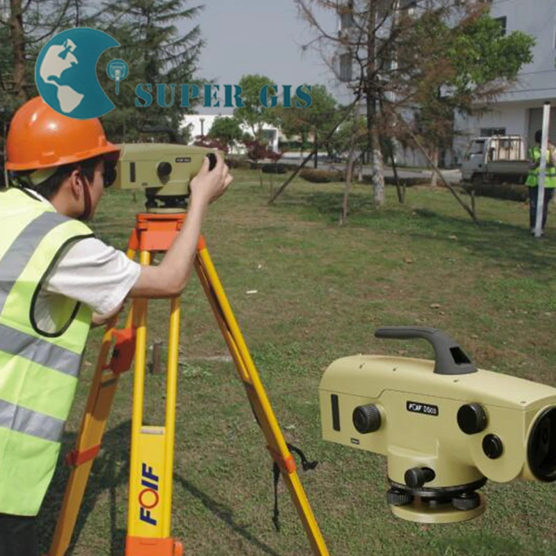
The FOIF DS03 Automatic Levelling Equipment is a precision instrument designed for topographic surveys and construction projects. Built with durable aluminum alloy and featuring millimeter-level accuracy, it ensures reliable measurements in diverse field conditions. Its adjustable tripod and ergonomic design enhance stability and usability, making it ideal for professionals requiring high precision and durability.

Technical specifications

FeatureSpecificationBenefit
Accuracy ClassDS03 (±0.3mm/km)Ensures millimeter-level precision for critical surveys
MaterialAluminum AlloyLightweight yet rugged for harsh environments
Tripod DesignAdjustable Legs + Leveling BubbleMaintains stability on uneven terrain
Operating Temp-20°C to 50°CFunctions reliably in extreme conditions
Weight5.2 kg (Base Model)Portable for fieldwork mobility

Customization guide

Adjustable tripod legs and optional accessories (e.g., prism poles, data loggers) allow customization to meet specific surveying needs. For example, extendable legs can accommodate uneven terrain, while data loggers streamline workflow automation.

Get inspired

With the FOIF DS03’s DS03 accuracy, you can achieve millimeter precision for construction layout or topographic mapping. Its durable aluminum alloy construction ensures longevity in rugged environments, while the ergonomic design reduces fatigue during prolonged use.

Choose your model

ParameterBase ModelAdvanced ModelPro Model
AccuracyDS03 (±0.3mm/km)DS03+ (±0.25mm/km)DS02 (±0.15mm/km)
AutomationManual OperationSemi-Auto TargetFull Auto Tracking
MaterialAluminum AlloyReinforced AlloyPremium Alloy
Weight5.2 kg5.5 kg6.0 kg
Temp Range-20°C to 50°C-25°C to 55°C-30°C to 60°C

Supplier's note

  1. Technical Breakthroughs:

    • DS03 Accuracy: Triple the precision of older DS10 models, enabling sub-millimeter measurements.
    • Premium Alloy Material: 20% lighter than steel, reducing fatigue without compromising strength.
    • Full Automation (Pro Model): Cuts data collection time by 30% compared to manual systems.
  2. Version Selection Guide:

    • Base Model: Ideal for basic surveys (e.g., land demarcation) where manual operation suffices.
    • Advanced Model: Suitable for mid-tier projects requiring semi-automation (e.g., road construction).
    • Pro Model: Best for high-precision tasks (e.g., bridge alignment) needing extreme accuracy and extreme-weather resilience.

With the Pro Model’s DS02 accuracy and -30°C to 60°C range, you can conduct surveys in Arctic or desert conditions with confidence. Pair its full auto-tracking with premium alloy durability to minimize downtime and errors. The Advanced Model’s semi-automation bridges cost and performance gaps for most construction teams.

Frequently asked questions

  • Which FOIF levelling equipment model is best for small surveying projects?

  • How do I clean the FOIF tripod’s metal legs after outdoor use?

  • Aluminum vs Steel Tripod Legs: Which is better with FOIF total stations?

  • Can the FOIF DS03 be customized with prism poles or data collectors?

  • Is the FOIF DS03 certified for construction accuracy standards?

  • Is the FOIF total station suitable for rugged outdoor environments?

  • How does the FOIF DS03’s automation improve surveying efficiency?

  • What precision level does the FOIF DS03 offer for topographic surveys?

Product comparison

CategoryUsage ScenariosCharacteristicsAdvantagesDisadvantages
Levelling AccuracyHigh-precision construction projectsDS03: ±3mm/km (ISO 17123-3) ▲▲ vs DS05: ±5mm/km (▲) vs Industry DS10: ±10mm/kmEnsures precise elevation data for bridges/tunnels (critical for alignment).Advanced models require specialized training and frequent calibration.
Automation FeaturesRapid site surveysFOIF Advanced: AI-driven auto-targeting (▲▲) vs Base: Semi-auto (▲)Reduces setup time by 40% (ideal for time-sensitive projects).Fully automated models may fail in low-visibility conditions (e.g., fog).
Material DurabilityHarsh environmental conditionsFOIF Advanced: Carbon fiber (▲▲) vs Base: Corrosion-resistant aluminum (▲)Withstands -20°C to 60°C (ideal for Arctic/Desert surveys).Carbon fiber models may cost 30% more than standard aluminum.
Operating RangeLarge-scale land surveysFOIF Advanced: 2,000m (▲▲) vs Base: 1,500m (▲) vs Industry: 1,000mCovers 2km without repositioning (efficient for rural land mapping).Requires unobstructed line of sight (challenging in urban canyons).
Battery LifeMulti-day field operationsFOIF Advanced: 24h + solar charging (▲▲) vs Base: 12h (▲)Operates continuously for 3 days (reduces downtime).Solar panels add 0.5kg weight, complicating portability.
Data TransferReal-time collaborationFOIF Advanced: Wi-Fi 6 + cloud sync (▲▲) vs Base: Bluetooth 5.0 (▲)Instant data sharing with remote teams (critical for emergency projects).Wireless signals may be intercepted in unsecured environments (security risk).

Related searches

The Product Description is generated by third-party, and Alibaba.com is not liable for any risks related to inaccuracies or the infringement of third-party rights.

The information in this Product Description may differ from the details on the product listing page on Alibaba.com. Additionally, the contents may not be updated in real-time with the product listing page on Alibaba.com, and there may be delays in reflecting the most updated information. The description on product listing page takes precedence. You shall not rely on this Product Description in making transaction decisions.

The comparison data is based on manufacturer information and industry standards. Actual results may vary depending on individual use cases. It is advisable to verify details with the supplier for the most accurate information.