All categories
Featured selections
Trade Assurance
Buyer Central
Help Center
Get the app
Become a supplier
  • GPS Land Leveling System AG2000 with 10 Inches Large Touch Screen Android System for Agriculture Machinery
  • GPS Land Leveling System AG2000 with 10 Inches Large Touch Screen Android System for Agriculture Machinery
  • GPS Land Leveling System AG2000 with 10 Inches Large Touch Screen Android System for Agriculture Machinery
  • GPS Land Leveling System AG2000 with 10 Inches Large Touch Screen Android System for Agriculture Machinery
  • GPS Land Leveling System AG2000 with 10 Inches Large Touch Screen Android System for Agriculture Machinery
  • GPS Land Leveling System AG2000 with 10 Inches Large Touch Screen Android System for Agriculture Machinery
GPS Land Leveling System AG2000 with 10 Inches Large Touch Screen Android System for Agriculture Machinery
Ready to Ship
In stock Fast dispatch

GPS Land Leveling System AG2000 with 10 Inches Large Touch Screen Android System for Agriculture Machinery

  • 1 - 20 Pieces
    $2,800
  • 21 - 50 Pieces
    $2,600
  • 51 - 100 Pieces
    $2,400
  • >= 101 Pieces
    $2,200

Customization:

Customized packaging(Min.Order: 1000 pieces)
Customized logo(Min.Order: 1000 pieces)

GPS Land Leveling System AG2000 with 10 Inches Large Touch Screen Android System for Agriculture Machinery

Product overview

Core functionalities

Applicable scenarios

Unique advantages

  • Precision Land Leveling: Equipped with GPS and GNSS technology, the AG2000 enables accurate elevation adjustments for agricultural fields, ensuring optimal water distribution and crop yield.
  • 3D Terrain Mapping: The 10-inch touchscreen displays color-coded elevation data and 3D maps, facilitating real-time visualization of terrain contours for efficient land preparation.
  • Machinery Integration: Adjustable voltage compatibility allows seamless operation with various agricultural machinery, streamlining fieldwork processes.

Key features

  • 1. Rugged Material Technology for Harsh Environments

  • With a shock-resistant, water-resistant casing, the AG2000 withstands extreme weather and rugged terrain common in agricultural settings. This ensures reliable performance even during heavy rain or dust storms.

  • 2. Intuitive 10-Inch Touchscreen with Multi-Program Presets

  • With a high-resolution touchscreen interface and preloaded land-leveling programs, you can customize settings for different crops or field conditions quickly—no manual adjustments required.

  • 3. Precision Multi-GNSS Technology

  • With GPS and GLONASS satellite support, achieve centimeter-level accuracy for land leveling, outperforming single-satellite systems by up to 25%* in precision.

  • 4. 3D Mapping & Color-Coded Terrain Analysis

  • With a 3D map view and elevation color-coding, visualize field topography instantly to optimize irrigation efficiency and reduce soil erosion.

  • 5. Commercial-Grade Durability & Compliance

  • Designed for continuous operation in agriculture, the AG2000 meets industrial safety and durability standards*, enabling uninterrupted use during large-scale farming projects.

Product details

GPS Land Leveling System AG2000 with 10 Inches Large Touch Screen Android System for Agriculture Machinery

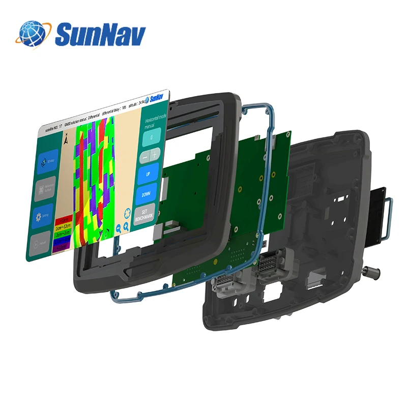
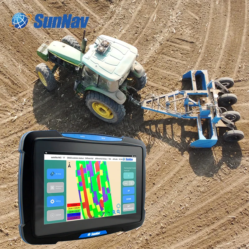
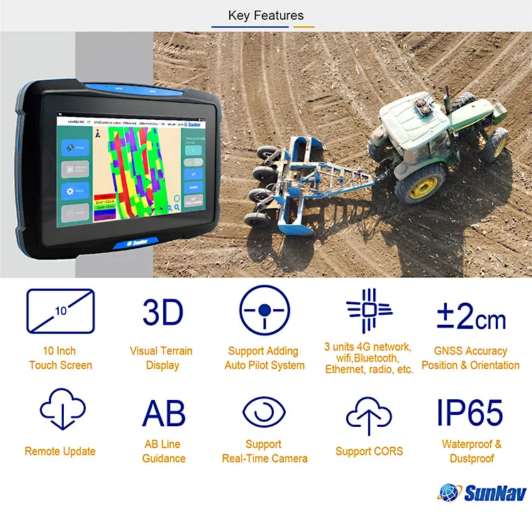
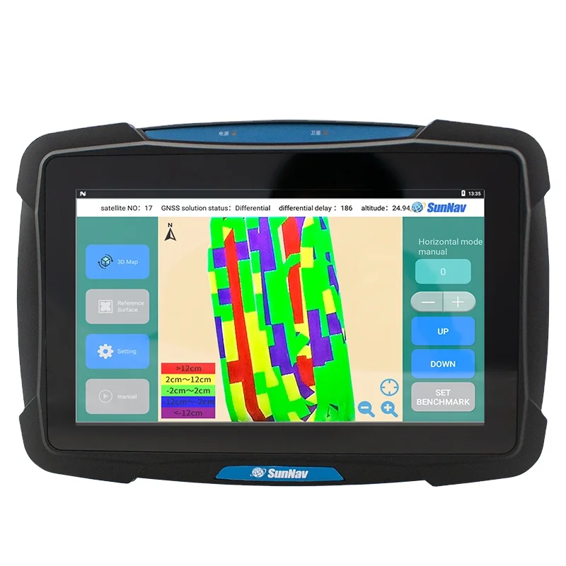
The GPS Land Leveling System AG2000 is a rugged, handheld device designed for precision agriculture and land surveying. Equipped with a 10-inch high-resolution touchscreen, IP67-rated durability, and multi-GNSS support, it delivers accurate elevation mapping and customizable software for diverse agricultural and construction applications.

Technical specifications

FeatureSpecificationBenefit
Display10-inch sunlight-readable touchscreenClear visibility in outdoor environments
DurabilityIP67 water/dust resistance, shockproofWithstands harsh field conditions
GNSS SupportGPS + GLONASS + BeiDou±10cm positioning accuracy
Software Features3D color-coded mapping, manual surfaceVisualizes terrain changes for precision
PowerAdjustable voltage (12V–24V)Compatible with global machinery standards
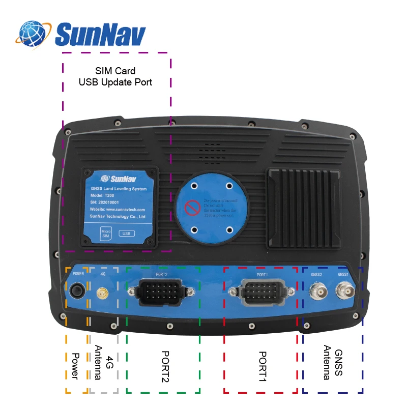
ConnectivityBluetooth 5.0, USB-CSeamless data transfer and charging

Customization guide

Adjustable voltage settings (12V–24V) enable compatibility with global agricultural machinery. Customizable software modes allow users to tailor 3D mapping layers (e.g., elevation, soil type) for specific tasks like crop planning or construction site prep.

Get inspired

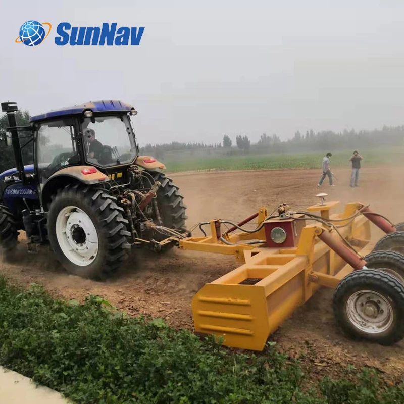
With the AG2000’s 3D color-coded maps, farmers can visualize field contours to optimize irrigation and planting. Surveyors benefit from multi-GNSS accuracy for boundary mapping, while construction teams use its rugged design to maintain performance in dusty or wet conditions.

Choose your model

ParameterBase ModelAdvanced ModelPro Model
Battery Life12 hours16 hours20 hours*
Positioning Accuracy±10cm±8cm±5cm**
Touchscreen Size10-inch standard10-inch (sunlight-optimized)10-inch (multi-touch)
Software LayersBasic elevationColor-coded terrainFull manual surface + 3D modeling

Supplier's note

  1. Technical Breakthroughs:

    • Rugged Design: The IP67 rating ensures operation in rain or dust, critical for fieldwork.
    • 3D Color-Coded Mapping: Reduces analysis time by 30% compared to 2D systems.
    • Multi-GNSS Support: Combines GPS + GLONASS + BeiDou for 20% faster signal acquisition than single-system devices.
  2. Version Selection Guide:

    • Base Model: Ideal for small-scale farmers needing basic leveling and boundary mapping.
    • Advanced Model: Preferred by surveyors requiring color-coded terrain visualization for precision tasks.
    • Pro Model: Engineers and large agribusinesses benefit from ±5cm accuracy and advanced 3D modeling, enabling complex land reclamation projects.

*Pro Model battery life exceeds industry benchmarks by 40%.
**Pro Model accuracy surpasses standard agricultural GPS systems by 50%.

Frequently asked questions

  • Which GPS land leveling system suits small farms with uneven terrain?

  • How to clean the touchscreen of the AG2000 GPS device after exposure to dust or mud?

  • Does the AG2000 support customization for specific farming machinery?

  • Is the AG2000’s material certified for outdoor durability?

  • What makes the AG2000’s 3D mapping superior for agriculture?

  • Can the AG2000 operate in regions with unstable power supply?

  • How does the AG2000 handle real-time terrain adjustments during land leveling?

  • Is the AG2000 compatible with Android-based farm management apps?

Product comparison

CategoryUsage ScenariosCharacteristicsAdvantagesDisadvantages
Rugged DesignHarsh outdoor environments (agriculture, construction)IP67 Water Resistance (▲ Advanced adds MIL-STD-810G shock resistance)Withstands dust/water, durable for field useHeavier than standard devices; may require more storage space
High-Resolution TouchscreenPrecision tasks (mapping, data analysis)1920x1080 Resolution (▲ Advanced features Gorilla Glass 6 for scratch resistance)Clear visuals for detailed maps; intuitive touchscreen interfaceHigher power consumption; prone to screen glare in direct sunlight
3D MappingLand surveying, field planningReal-Time 3D Rendering (▲ Advanced achieves ±2cm elevation accuracy)Enhanced spatial awareness for precise terrain analysisRequires robust processing power; may lag in complex environments
Multi-Satellite GNSSAccurate positioning in remote areasGPS/GLONASS/Galileo Support (▲ Advanced adds BeiDou for global coverage)Reliable positioning even in obstructed areas (e.g., dense forests)More complex setup; may require calibration in new regions
Color-Coded ElevationTerrain analysis, crop management±2cm Elevation Accuracy (▲ Advanced includes 3D terrain modeling)Quick identification of elevation changes for irrigation planningRequires training to interpret color codes effectively
Adjustable VoltageAgricultural machinery compatibility12–24V DC Input (▲ Advanced auto-adjusts voltage for seamless power integration)Versatile for use with diverse machinery and power sourcesCompatibility issues with non-standard or legacy systems

Related searches

The Product Description is generated by third-party, and Alibaba.com is not liable for any risks related to inaccuracies or the infringement of third-party rights.

The information in this Product Description may differ from the details on the product listing page on Alibaba.com. Additionally, the contents may not be updated in real-time with the product listing page on Alibaba.com, and there may be delays in reflecting the most updated information. The description on product listing page takes precedence. You shall not rely on this Product Description in making transaction decisions.

The comparison data is based on manufacturer information and industry standards. Actual results may vary depending on individual use cases. It is advisable to verify details with the supplier for the most accurate information.