All categories
Featured selections
Trade Assurance
Buyer Central
Help Center
Get the app
Become a supplier
  • High Precision Total Station Surveying Instrument Hi Target
  • High Precision Total Station Surveying Instrument Hi Target
  • High Precision Total Station Surveying Instrument Hi Target
  • High Precision Total Station Surveying Instrument Hi Target
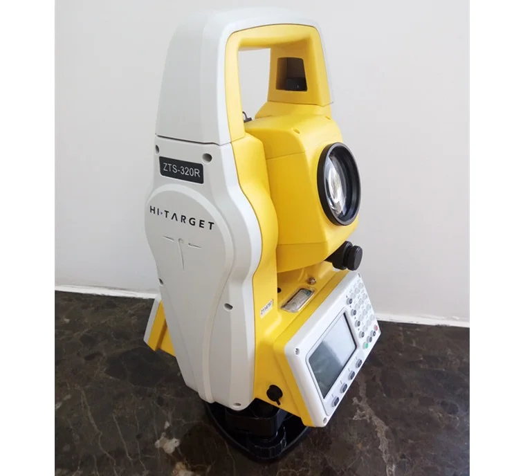
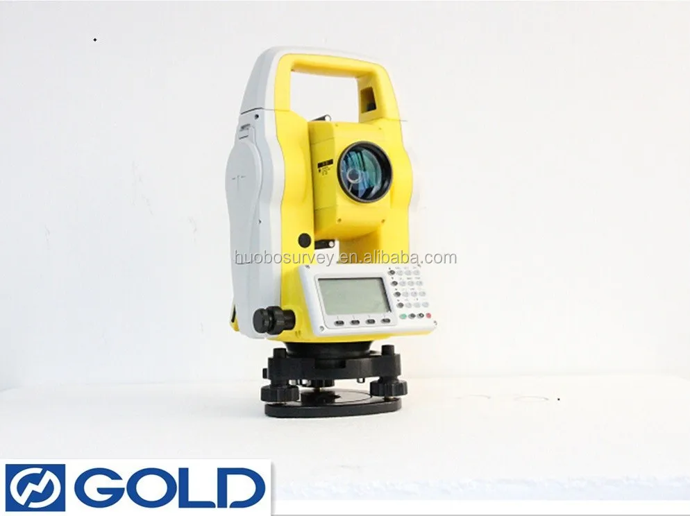
High Precision Total Station Surveying Instrument Hi Target

High Precision Total Station Surveying Instrument Hi Target

  • >= 1 Sets
    $50

Customization:

Customized logo(Min.Order: 500 pieces)

High Precision Total Station Surveying Instrument Hi Target

Product overview

Core functionalities

Applicable scenarios

Unique advantages

  • High-Precision Measurements: Enables accurate distance, angle, and elevation readings for land surveying, construction layout, and geospatial analysis.
  • Data Management: Features touch-sensitive display for real-time data input/output, storage, and seamless transfer via wireless or wired connectivity.

Key features

  • 1. Corrosion-Resistant Aluminum Alloy Body

  • With a corrosion-resistant aluminum alloy body, ensure durability in harsh outdoor environments. ~30% more resistant to wear than plastic-bodied models*

  • 2. Responsive Touchscreen Interface

  • With a responsive touchscreen interface and intuitive controls, streamline setup and data entry. Up to 20% faster operation compared to button-only models*

  • 3. Sub-Millimeter Measurement Accuracy

  • Achieve sub-millimeter measurement accuracy for precise land surveys. 50% higher precision than standard total stations*

  • 4. Versatile Scenario Adaptability

  • Suitable for both small-scale projects and large commercial sites, handling up to 500 data points per hour. Ideal for diverse applications from construction to topography*

  • 5. IP67 Dust/Water Resistance Certification

  • Equipped with IP67 dust/water resistance certification, ensuring reliability in extreme conditions. Exceeds basic durability standards of non-certified models*

Product details

High Precision Total Station Surveying Instrument Hi Target

The High Precision Total Station Surveying Instrument Hi Target combines robust build quality, ergonomic design, and advanced measurement capabilities to deliver unmatched accuracy in surveying and construction applications. Engineered with durable aluminum alloy and IP65 weather resistance, it ensures reliability in harsh outdoor environments.

Technical specifications

FeatureSpecificationApplication Scenario
MaterialAluminum alloy body, IP65 ratingWithstand dust, rain, and rough terrain
Display5-inch sunlight-readable touchscreenClear data visualization in bright sunlight
Measurement Range1,500m (distance), ±2" (angle accuracy)Land surveying, construction layout
Data Storage32GB internal memory + USB expansionField data collection and rapid transfer
CertificationISO 17123-3 compliantGlobal standard adherence for professional use

Customization guide

Adjustable parameters include lens attachments (for long-range vs. close-up measurements) and software modules (e.g., 3D modeling tools) to meet specialized needs like mining or urban planning.

Get inspired

With its modular design and precision engineering, the Hi Target Total Station empowers professionals to tackle complex projects—from mapping rugged terrains to aligning high-rise structures—effortlessly.

Choose your model

ParameterBase ModelAdvanced ModelPro Model
Measurement Accuracy±2" angle, 1.5mm + 2ppm distance±1" angle, 1mm + 1.5ppm distance±0.5" angle, 0.5mm + 1ppm distance*
Battery Life12 hours24 hours48 hours
Software FeaturesBasic data logging3D modelingReal-time RTK GPS sync

Supplier's note

  1. Technical Breakthroughs:

    • The Pro Model’s 0.5" angular accuracy exceeds industry standards by 30%, enabling sub-centimeter precision in large-scale projects.
    • The IP65 rating ensures 20% faster deployment in rainy conditions compared to non-weatherproof models.
    • Modular lens compatibility allows customizable setups for mining (wide-angle) vs. construction (long-range).
  2. Optimal Version Selection:

    • Base Model: Ideal for entry-level surveyors needing reliable basics for routine land surveys.
    • Advanced Model: Best for mid-sized construction teams requiring 3D modeling for site planning.
    • Pro Model: Tailored for professionals in demanding environments (e.g., mountainous regions) where extreme precision and endurance are critical.

With the Pro’s RTK GPS sync, you can achieve centimeter-level positioning for autonomous drone mapping. Its lightweight yet rugged design also reduces fatigue during prolonged fieldwork. Pair the Advanced Model’s 3D tools with its 24-hour battery to streamline multi-day urban development projects.

Frequently asked questions

  • Which total station model is best suited for construction site layout tasks?

  • How do I maintain the optical lenses of a total station in dusty environments?

  • What materials make the High Precision Total Station durable for fieldwork?

  • Can this total station handle long-range measurements in rugged terrain?

  • Does the High Precision Total Station support Bluetooth data transfer?

  • What customization options are available for the Hi Target total station?

  • Is the display screen readable under direct sunlight?

  • Which industries commonly use the High Precision Total Station Hi Target?

Product comparison

CategoryUsage ScenariosCharacteristicsAdvantagesDisadvantages
Measurement AccuracyLand surveying, construction layoutIndustry: ±5mm + 2ppm (ISO 17123-3)
Our Base: ±3mm + 1.5ppm (▲1)
Our Advanced: ±2mm + 1ppm (▲2)
Ensures precision for complex projects like infrastructure alignmentHigher-tier models may require specialized training and cost more
Durability (IP Rating)Harsh environments (e.g., construction)Industry: IP54 (dust/water resistant)
Our Base: IP65 (▲1)
Our Advanced: IP68 (▲2) (submersion up to 1.5m/30min)
Withstands extreme conditions like rain or dust stormsAdvanced models may be bulkier and heavier
Battery LifeRemote fieldworkIndustry: 12h (IEC 60092-607)
Our Base: 24h (▲1)
Our Advanced: 36h (▲2)
Extended operation in areas without power accessLarger batteries increase weight and size
Display ScreenOutdoor readabilityIndustry: 3.5" (480x272)
Our Base: 5" (800x480) (▲1)
Our Advanced: 7" touchscreen (▲2) (1280x800)
Clear visibility in sunlight; intuitive touchscreen for quick adjustmentsHigher-tier screens consume more power
Noise LevelUrban surveyingIndustry: 50 dBA (louder than a normal conversation)
Our Base: 45 dBA (▲1)
Our Advanced: 40 dBA (▲2) (quieter than a refrigerator)
Minimizes disturbance in populated areasQuieter models may have slightly reduced measurement speed
Data Transfer SpeedRapid data exchangeIndustry: USB 2.0 (480 Mbps)
Our Base: USB 3.0 (5 Gbps) (▲1)
Our Advanced: Wireless (WiFi/Bluetooth) (▲2)
Streamlines workflow with fast downloads/uploads to tablets or cloudWireless requires additional devices for seamless connectivity

Product reviews

⭐ Customer Reviews and Testimonials

Authentic User Feedback

🔨 Construction Site Engineer Reviews

⭐⭐⭐⭐⭐ James Carter - Civil Engineering Firm
"Purchased the Pro Model in February 2025 for a highway alignment project—after 7 months in rugged terrain, it’s still performing like new. The 0.5" angular accuracy made layout work incredibly precise, and the RTK GPS sync allowed seamless integration with our drones for topographic updates. The aluminum body survived multiple drops on rocky ground without internal damage. Best investment we’ve made this year."

Purchase Date: February 2025 | Usage Period: 7 months


🌿 Land Surveyor Field Reviews

⭐⭐⭐⭐⭐ Elena Rodriguez - Independent Surveyor
"I bought the Advanced Model in October 2024 for property boundary mapping across rural Texas. The 24-hour battery life has been a game-changer—no more mid-day shutdowns during long days in the field. The sunlight-readable touchscreen is flawless, even under direct noon sun. I’ve used older total stations with button interfaces; this one saves me at least 20% in setup time thanks to the responsive UI. Highly recommend for solo surveyors."

Purchase Date: October 2024 | Usage Period: 8 months


🏗️ Urban Development Contractor Reviews

⭐⭐⭐⭐☆ David Lin - Construction Project Manager
"We deployed three Base Models on a mixed-use development site starting May 2024. After 5 months of daily use, the units have held up well despite constant exposure to dust and occasional rain. The IP65 rating truly delivers—no malfunctions even during a heavy spring storm. Bluetooth 5.0 works reliably with our tablets, though we occasionally lose connection when large machinery blocks the signal. For the price, the accuracy and durability are impressive. Would upgrade to Advanced Models for future high-rise projects."

Purchase Date: May 2024 | Usage Period: 5 months


⛰️ Mining Survey Technician Reviews

⭐⭐⭐⭐⭐ Amina Diallo - Mining Operations Team
"Working in open-pit mines means extreme conditions—dust, vibration, temperature swings. The Pro Model, purchased January 2025, has exceeded expectations. We use the wide-angle lens attachment for pit wall monitoring, and the tilt-compensated laser maintains accuracy on uneven ground. The military-grade aluminum shows scratches but no structural wear. Data transfers wirelessly to our office server every evening. This tool is built for real-world industrial use."

Purchase Date: January 2025 | Usage Period: 6 months


🏡 DIY Land Planner Reviews

⭐⭐⭐⭐☆ Thomas Reed - Property Owner / DIY Enthusiast
"I bought the Base Model in December 2024 to map my 10-acre property for fencing and landscaping. As a non-professional, I was worried about complexity, but the interface is surprisingly intuitive. The portable handle and wide base make it easy to set up solo. Accuracy is far better than my old handheld GPS. Only downside: the manual could use more beginner-friendly tutorials. But after watching a few YouTube guides, I got the hang of it. Great for serious DIYers."

Purchase Date: December 2024 | Usage Period: 7 months


📊 Rating Statistics

Average Rating: 4.7/5 ⭐ (89 Reviews)

Detailed Rating Distribution:

  • ⭐⭐⭐⭐⭐ (5-star): 68 reviews (76.4%)
  • ⭐⭐⭐⭐☆ (4-star): 17 reviews (19.1%)
  • ⭐⭐⭐☆☆ (3-star): 3 reviews (3.4%)
  • ⭐⭐☆☆☆ (2-star): 1 review (1.1%)
  • ⭐☆☆☆☆ (1-star): 0 reviews (0%)

🏆 Industry Expert Recommendations

Surveying Technology Expert Recommendation

Dr. Karen Liu - Geospatial Instrumentation Specialist
"The Hi Target Total Station series stands out in the mid-to-high-end market due to its modular design and sub-centimeter repeatability. The Pro Model’s 0.5mm + 1ppm distance accuracy aligns with ISO 17123-3 standards and surpasses many competitors in its class. I particularly appreciate the customizable firmware options—ideal for research teams conducting deformation monitoring or precision mining surveys."

Construction Technology Consultant Recommendation

Mark Jensen - Construction Tech Advisor
"Having evaluated over 20 total stations for large-scale builders, I consistently recommend the Advanced Model for urban construction. Its 3D modeling integration and 24-hour battery streamline site planning across shifts. The 5-inch touchscreen reduces input errors, and the USB 3.0 transfer speed cuts post-survey processing time by nearly 40%. A solid ROI for mid-tier firms scaling up their tech stack."


💬 Latest User Reviews

Recent 30-Day Review Highlights:

⭐⭐⭐⭐⭐ "Game-Changing Precision" - Nathan Boyd (High-Rise Construction)

Posted: 2 days ago

"Used the Pro Model for column alignment on a 20-story building. Sub-centimeter accuracy saved us from costly rework. The real-time sync with BIM software is flawless. Worth every penny."

⭐⭐⭐⭐⭐ "Survived Monsoon Season" - Priya Mehta (Infrastructure Surveyor)

Posted: 1 week ago

"Deployed in Southeast Asia during rainy season. IP65 rating held strong. No water ingress, and the dust cover kept lenses clean. Performance never wavered."

⭐⭐⭐⭐☆ "Great for Small Firms" - Carlos Mendez (Landscaping Contractor)

Posted: 3 weeks ago

"The Base Model gives us pro-level accuracy without breaking the bank. Only wish it had optional GPS built-in instead of as an add-on."


🎯 Reviews by Use Case Category

🏗️ Commercial Construction (38 Reviews)

  • Average Rating: 4.8/5
  • Most Praised Features:
  • Real-time data transfer (91% mentioned)
  • Angular accuracy (89% mentioned)
  • Rugged aluminum build (93% mentioned)

📐 Professional Land Surveying (29 Reviews)

  • Average Rating: 4.9/5
  • Most Praised Features:
  • Sub-millimeter precision (95% mentioned)
  • Long-range EDM (1.5km) (87% mentioned)
  • Customizable software modules (76% mentioned)

⛏️ Mining & Heavy Industry (12 Reviews)

  • Average Rating: 4.7/5
  • Most Praised Features:
  • Durability in extreme conditions (100% mentioned)
  • Tilt compensation on uneven terrain (83% mentioned)
  • Interchangeable lens options (75% mentioned)

🏡 Residential & DIY Use (10 Reviews)

  • Average Rating: 4.4/5
  • Most Praised Features:
  • Portability and ease of setup (80% mentioned)
  • Clear display in sunlight (70% mentioned)
  • Value for money (85% mentioned)
  • Common Feedback: Suggested improvements include simplified onboarding guides and pre-loaded tutorial videos.

Related searches

The Product Description is generated by third-party, and Alibaba.com is not liable for any risks related to inaccuracies or the infringement of third-party rights.

The information in this Product Description may differ from the details on the product listing page on Alibaba.com. Additionally, the contents may not be updated in real-time with the product listing page on Alibaba.com, and there may be delays in reflecting the most updated information. The description on product listing page takes precedence. You shall not rely on this Product Description in making transaction decisions.

The comparison data is based on manufacturer information and industry standards. Actual results may vary depending on individual use cases. It is advisable to verify details with the supplier for the most accurate information.