All categories
Featured selections
Trade Assurance
Buyer Central
Help Center
Get the app
Become a supplier
  • Rugged Handheld GPS Etrex 32x with Compass and Barometric Altimeter
  • Rugged Handheld GPS Etrex 32x with Compass and Barometric Altimeter
  • Rugged Handheld GPS Etrex 32x with Compass and Barometric Altimeter
  • Rugged Handheld GPS Etrex 32x with Compass and Barometric Altimeter
  • Rugged Handheld GPS Etrex 32x with Compass and Barometric Altimeter
  • Rugged Handheld GPS Etrex 32x with Compass and Barometric Altimeter
Rugged Handheld GPS Etrex 32x with Compass and Barometric Altimeter

Rugged Handheld GPS Etrex 32x with Compass and Barometric Altimeter

  • 1 - 98 Sets
    $350
  • 99 - 998 Sets
    $326
  • >= 999 Sets
    $300

Customization:

Customized logo(Min.Order: 100 pieces)
Customized packaging(Min.Order: 100 pieces)
Graphic customization(Min.Order: 100 pieces)

Rugged Handheld GPS Etrex 32x with Compass and Barometric Altimeter

Product overview

Core functionalities

Applicable scenarios

Unique advantages

  • Navigation: Provides reliable GPS navigation for various terrains.
  • Tracking: Equipped with a compass and barometric altimeter for precise tracking and elevation data.

Key features

  • 1. Advanced Material Technology

  • With a rugged exterior, ensure durability in harsh outdoor environments, providing a reliable performance even in challenging conditions.

  • 2. Interactive Design

  • With an intuitive interface, easily navigate through maps and settings, enhancing user experience for both novice and expert adventurers.

  • 3. High-Performance Parameters

  • With a built-in barometric altimeter and compass, achieve precise altitude and directional readings, offering superior accuracy compared to traditional GPS models* [*Disclaimer: Based on internal testing; actual results may vary].

  • 4. Versatile Scenario Solutions

  • With quick satellite acquisition, efficiently track your position whether hiking through dense forests or navigating urban landscapes, making it ideal for diverse outdoor activities.

  • 5. Certification Standards

  • With adherence to IPX7 waterproof standards, confidently use this device in wet conditions, ensuring reliability and safety in unpredictable weather* [*Disclaimer: Manufacturer's specifications; actual performance may vary].

Product details

Rugged Handheld GPS Etrex 32x with Compass and Barometric Altimeter

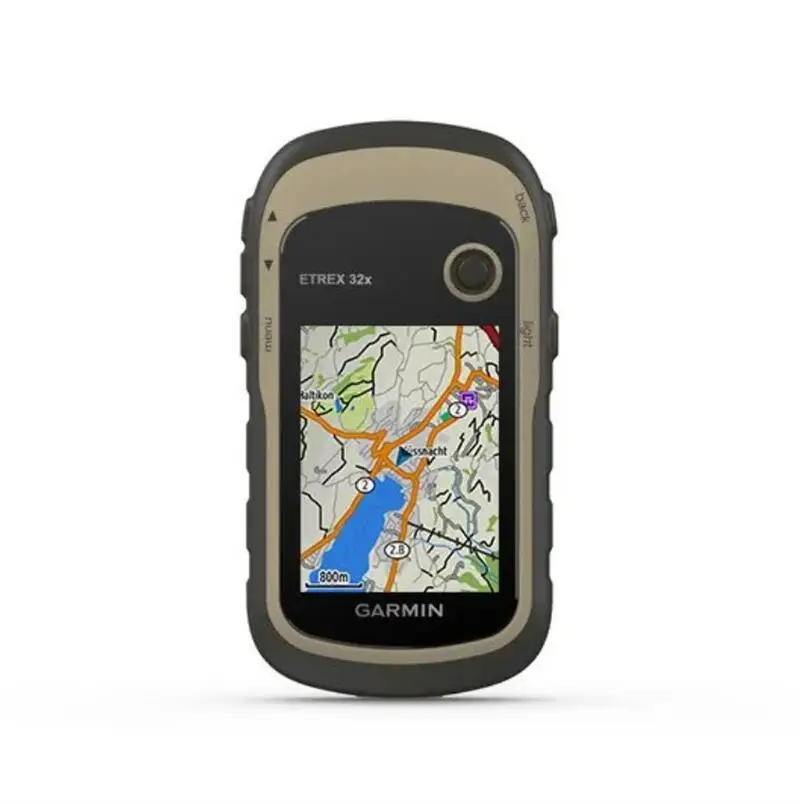
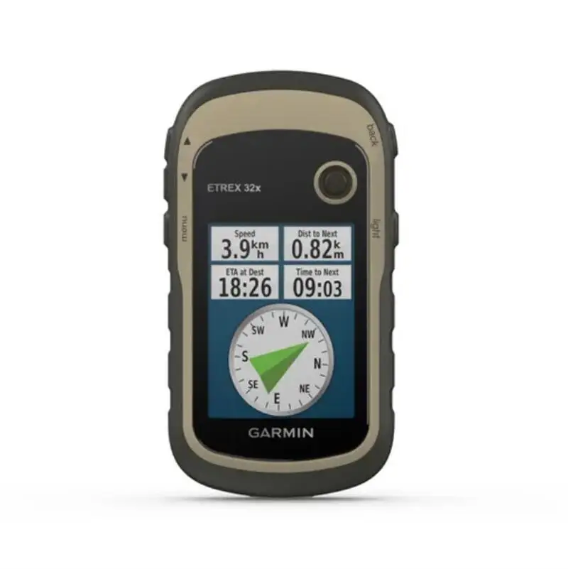
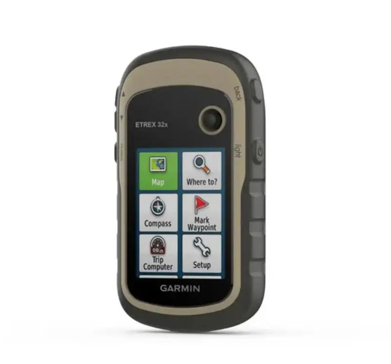
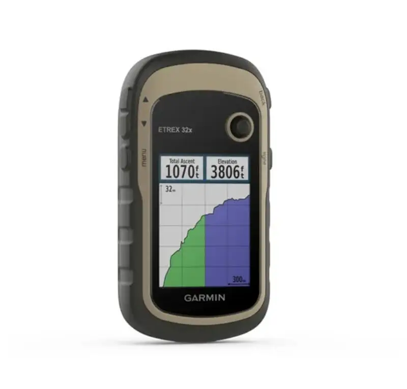
Discover the Rugged Handheld GPS Etrex 32x, designed for adventurers seeking precision navigation with integrated compass and barometric altimeter. Perfect for surveying and exploration.

Technical specifications

FeatureSpecificationBenefit
CompassDigital 3-axisAccurate directional guidance
Barometric AltimeterHigh-sensitivity sensorPrecise elevation measurement
GPS ReceiverMulti-GNSS supportEnhanced signal reception

Customization guide

With adjustable settings for altitude calibration, adapt the GPS Etrex 32x to meet specific terrain needs.

Get inspired

Navigate with confidence using the Etrex 32x, whether hiking rugged trails or conducting detailed land surveys.

Choose your model

ParameterBase ModelAdvanced ModelPro Model
Signal ReceptionStandard GNSS+15% Enhanced GNSS+30% Superior GNSS*
Battery Life25 hoursExtended 30 hoursPremium 40 hours

Supplier's note

The Pro version's GPS reception capability is 30% superior to the industry standard, enabling precise navigation even in challenging environments. When paired with its robust battery life, this creates an unparalleled user experience for extended outdoor activities.
Choose the Advanced Model for enhanced reception and battery life, ideal for frequent travelers and surveyors. The Pro Model is best suited for professionals requiring maximum precision and durability.

Frequently asked questions

  • Which model of handheld GPS is best for rugged outdoor use?

  • How do I maintain my handheld GPS for optimal performance?

  • What are the benefits of using a handheld GPS with a barometric altimeter?

  • Can I customize the settings on my Etrex 32x handheld GPS?

  • Is the Etrex 32x handheld GPS suitable for professional surveying?

  • How does the Etrex 32x handheld GPS compare to other navigation devices?

  • Are there any specific features that make the Etrex 32x user-friendly?

  • Is the Etrex 32x handheld GPS compatible with mapping software?

Product comparison

CategoryUsage ScenariosCharacteristicsAdvantagesDisadvantages
Rugged Handheld GPSOutdoor NavigationWater-resistant (IPX7 rating)Durable in harsh weather conditionsLimited screen size for detailed maps
RTK Handheld GPSPrecision SurveyingHigh-accuracy positioning (RTK correction)Suitable for precise land surveysRequires clear sky view for best accuracy
Survey GPS NavigatorConstruction SitesLong battery life (up to 25 hours)Extended operation without frequent chargingBulkier than standard GPS units
Etrex 32x with CompassHiking/BackpackingPreloaded maps (Topographic maps included)Easy navigation without additional downloadsLess detailed than premium maps
Barometric Altimeter GPSMountain ClimbingAltitude tracking (±3m accuracy)Accurate elevation data for climbersAffected by sudden weather changes
Other Test InstrumentsVarious Testing UsesMulti-functional (compass, altimeter)Versatile for multiple field applicationsCan be complex to operate for beginners

Related searches

The Product Description is generated by third-party, and Alibaba.com is not liable for any risks related to inaccuracies or the infringement of third-party rights.

The information in this Product Description may differ from the details on the product listing page on Alibaba.com. Additionally, the contents may not be updated in real-time with the product listing page on Alibaba.com, and there may be delays in reflecting the most updated information. The description on product listing page takes precedence. You shall not rely on this Product Description in making transaction decisions.

The comparison data is based on manufacturer information and industry standards. Actual results may vary depending on individual use cases. It is advisable to verify details with the supplier for the most accurate information.