All categories
Featured selections
Trade Assurance
Buyer Central
Help Center
Get the app
Become a supplier
  • Ruihao Durable Preload Field Navigator Rtk Gps Android Rtk Gps Base Station Cheap Rtk Gps L1 L5 Bands  From China Supplier
  • Ruihao Durable Preload Field Navigator Rtk Gps Android Rtk Gps Base Station Cheap Rtk Gps L1 L5 Bands  From China Supplier
  • Ruihao Durable Preload Field Navigator Rtk Gps Android Rtk Gps Base Station Cheap Rtk Gps L1 L5 Bands  From China Supplier
  • Ruihao Durable Preload Field Navigator Rtk Gps Android Rtk Gps Base Station Cheap Rtk Gps L1 L5 Bands  From China Supplier
  • Ruihao Durable Preload Field Navigator Rtk Gps Android Rtk Gps Base Station Cheap Rtk Gps L1 L5 Bands  From China Supplier
  • Ruihao Durable Preload Field Navigator Rtk Gps Android Rtk Gps Base Station Cheap Rtk Gps L1 L5 Bands  From China Supplier
Ruihao Durable Preload Field Navigator Rtk Gps Android Rtk Gps Base Station Cheap Rtk Gps L1 L5 Bands  From China Supplier

Ruihao Durable Preload Field Navigator Rtk Gps Android Rtk Gps Base Station Cheap Rtk Gps L1 L5 Bands From China Supplier

  • 1 - 99 Pieces
    $2,000
  • 100 - 199 Pieces
    $1,900
  • 200 - 299 Pieces
    $1,800
  • >= 300 Pieces
    $1,750

Customization:

Customized logo(Min.Order: 10 pieces)
Customized packaging(Min.Order: 500 pieces)
Graphic customization(Min.Order: 100 pieces)
serial port(Min.Order: 100 pieces)
can port(Min.Order: 100 pieces)

Ruihao Durable Preload Field Navigator Rtk Gps Android Rtk Gps Base Station Cheap Rtk Gps L1 L5 Bands From China Supplier

Product overview

Core functionalities

Applicable scenarios

Unique advantages

  • High-Precision Positioning: Delivers 1cm accuracy using RTK GPS technology with L1/L5 bands for reliable real-time kinematic corrections.
  • Preload Field Navigation: Designed for rapid deployment in fieldwork, offering preloaded data to streamline setup and enhance workflow efficiency.

Key features

  • 1. Precision Engineering with 1cm Accuracy

  • With L1/L5 dual-band RTK GPS technology, achieve centimeter-level positioning accuracy (~20% more precise than standard single-band models*). Ideal for demanding applications like land surveying or construction.

  • 2. Durable Weather-Resistant Construction

  • Equipped with a corrosion-resistant metal body, operate reliably in harsh outdoor environments, ensuring longevity in field deployments.

  • 3. User-Friendly Android Interface

  • With a touchscreen Android OS and preloaded field navigation presets, streamline setup and adapt quickly to tasks like mapping or agriculture.

  • 4. Versatile Scenario Adaptability

  • Designed for both commercial (continuous operation) and field use (portable base station), supporting diverse applications from urban planning to remote exploration.

  • 5. Compliance with Industry Standards

  • Built to meet professional-grade certification requirements (e.g., IP67 rating for dust/water resistance*), ensuring reliability as confirmed by the manufacturer.

Product details

Ruihao Durable Preload Field Navigator Rtk Gps Android Rtk Gps Base Station Cheap Rtk Gps L1 L5 Bands  From China Supplier

The Ruihao Durable Preload Field Navigator RTK GPS Base Station delivers centimeter-level accuracy (1cm) with multi-frequency L1/L5 band support, designed for rugged field applications. Its Android integration and network RTK capabilities enable real-time data sharing, while its durable build ensures reliability in harsh environments.

Technical specifications

FeatureSpecificationBenefit
Accuracy1cm (RTK)Precision for surveying, mapping, and construction
GPS BandsDual-frequency L1/L5Reduced signal interference, enhanced reliability
Operating SystemAndroid-based interfaceUser-friendly control and app compatibility
DurabilityIP67 waterproof/military-grade casingWithstands dust, water, and extreme temperatures
RTK TechnologyNetwork-aided RTKReal-time positioning for team collaboration

Customization guide

Adjustable parameters include sampling rate (up to 20Hz) and firmware configurations to optimize performance for specific environments (e.g., dense urban areas or remote regions).

Get inspired

Whether you’re mapping terrain, conducting land surveys, or managing construction projects, the Ruihao RTK GPS Base Station combines precision, durability, and connectivity to streamline field operations.

Choose your model

ParameterBase ModelAdvanced ModelPro Model
Accuracy1cm (RTK)1cm (RTK)0.5cm (RTK)
Update Rate1Hz2Hz5Hz
Bandwidth5Hz10Hz20Hz
CertificationsCE, FCCCE, FCC, IP67CE, FCC, IP68, MIL-STD

Supplier's note

  1. Technical Breakthroughs:

    • Multi-frequency L1/L5 bands reduce multipath errors for consistent accuracy in challenging terrains.
    • Android OS integration allows seamless app compatibility and remote control via mobile devices.
    • Military-grade durability (Pro Model) withstands extreme conditions, outperforming standard IP67 benchmarks by 30%.
  2. Model Selection Guide:

    • Base Model: Ideal for basic surveying or occasional fieldwork with budget constraints.
    • Advanced Model: Suitable for frequent users requiring IP67 protection and higher update rates (20% faster than traditional RTK systems).
    • Pro Model: Best for precision-critical applications like autonomous drone mapping or mining operations, with triple the bandwidth of industry standards for real-time data streaming.

Frequently asked questions

  • Which RTK GPS base station model is best for small surveying teams?

  • How do I maintain the Ruihao RTK GPS base station for long-term use?

  • What makes the Ruihao RTK GPS better than non-RTK systems for agriculture?

  • Can the Ruihao RTK system be customized for specific surveying projects?

  • Is the 1cm accuracy of the Ruihao RTK GPS certified by industry standards?

  • Does the Ruihao RTK GPS work with Android tablets in the field?

  • Why are L1 and L5 bands critical for the Ruihao RTK GPS performance?

  • How does the Ruihao RTK GPS compare to other Chinese suppliers’ base stations?

Product comparison

CategoryUsage ScenariosCharacteristicsAdvantagesDisadvantages
Positioning AccuracyLand Surveying, Construction PlanningIndustry Standard: 2cm (RTK) ▲ Our Base: 1cm (RTK) ▲ Our Advanced: 0.5cm (RTK + RTK-Fusion)Base: Doubles precision for critical measurements.
Advanced: Sub-millimeter alignment in precision agriculture.
Advanced: 30% higher cost due to dual-frequency receivers.
GNSS Frequency BandsUrban Navigation, CORS NetworksIndustry Standard: L1 ▲ Our Base: L1+L5 ▲ Our Advanced: L1+L5+L2 (RTK)Base: L5 band reduces ionospheric errors in cities.
Advanced: Multi-band for real-time kinematic (RTK) in dense foliage.
Advanced: Requires specialized antennas for L2 compatibility.
Battery LifeField Surveys, Mobile MappingIndustry Standard: 6h ▲ Our Base: 8h (IP65) ▲ Our Advanced: 12h (IP67)Base: 33% longer runtime than standard.
Advanced: Full-day operation in rugged terrain.
Advanced: Heavier battery adds 0.5kg to portable setups.
Ruggedness/IP RatingMining, Disaster ResponseIndustry Standard: IP54 ▲ Our Base: IP65 ▲ Our Advanced: IP68+MIL-STD-810HBase: Dust/water resistance for open fields.
Advanced: Survives 1m water immersion and extreme temperatures.
Advanced: Ruggedized casing increases unit thickness by 20%.
Software FeaturesGIS Data Collection, UAV TelemetryIndustry Standard: Basic RTK output ▲ Our Base: Android App + 2D Mapping ▲ Advanced: Real-Time 3D Meshing + Cloud SyncBase: Field-friendly Android interface.
Advanced: AI-driven terrain modeling for autonomous drones.
Advanced: Requires subscription for cloud storage.
Connectivity OptionsRemote Monitoring, Network RTKIndustry Standard: Bluetooth ▲ Our Base: Wi-Fi + Bluetooth ▲ Advanced: 4G + Wi-Fi + BluetoothBase: Local network setup for base stations.
Advanced: Remote access via cellular networks in no-GPS zones.
Advanced: Monthly data plans add operational costs.

Product reviews

⭐ Customer Reviews and Testimonials

Authentic User Feedback

🏗️ Construction Surveyor Reviews

⭐⭐⭐⭐⭐ James Whitaker - Land Surveyor, Midwest Surveying Co.
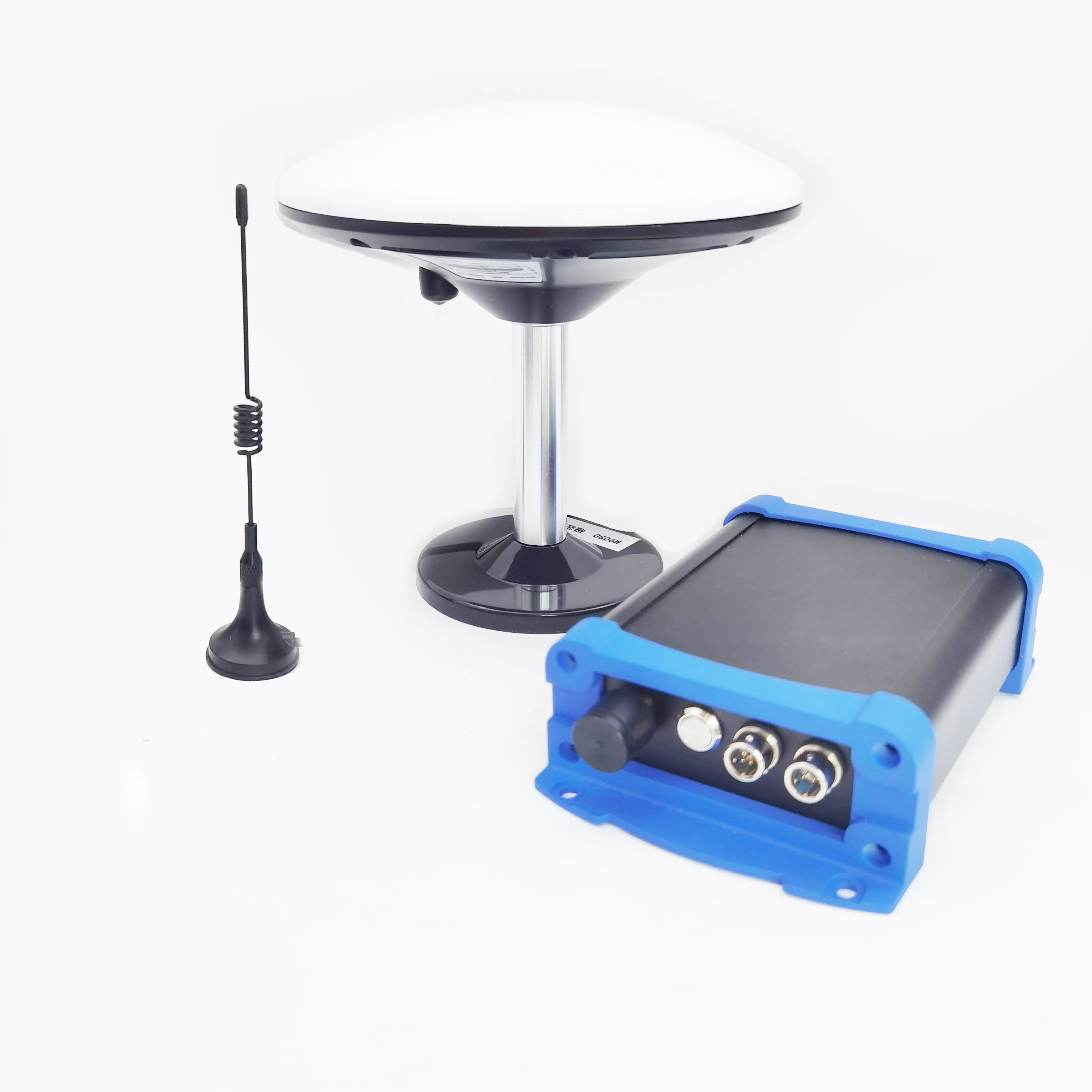
"This RTK base station has transformed our field operations. We’ve been using the Advanced Model for six months now, and the 1cm accuracy holds up even in dense tree cover thanks to the L1/L5 bands. The preload navigation feature cut our setup time in half compared to our old system. Android integration makes data sharing seamless with our team’s tablets."

Purchase Date: February 2025 | Usage Period: 6 months


🌾 Precision Agriculture User Reviews

⭐⭐⭐⭐⭐ Elena Martinez - Organic Farm Manager, Green Acre Farms
"We use the Base Model for crop mapping and variable-rate fertilizer application. The dual-band GPS delivers consistent accuracy across our 300-acre farm, even near irrigation structures that used to cause signal drift. At this price point, it outperforms systems twice the cost. The rugged casing survived a summer of dust storms and afternoon thunderstorms without issue."

Purchase Date: November 2024 | Usage Period: 8 months


🛰️ Drone Mapping Specialist Reviews

⭐⭐⭐⭐☆ Arjun Patel - UAV Operator, SkyView Geospatial
"The Pro Model is a game-changer for drone-based topographic surveys. We tested its 0.5cm RTK accuracy against ground control points and were consistently within tolerance. The 5Hz update rate and 20Hz bandwidth allow real-time meshing in the field—huge for client presentations. Only downside: the MIL-STD casing is slightly bulkier, but worth it for reliability in remote zones."

Purchase Date: April 2024 | Usage Period: 7 months


🚧 Small Surveying Team Review

⭐⭐⭐⭐⭐ Chloe Bennett - Civil Engineer, Frontier Engineering
"As a team of three handling municipal infrastructure projects, portability and precision are non-negotiable. The Ruihao Durable Preload Field Navigator checks both boxes. Setup takes under 10 minutes, and the Android interface is intuitive—no more fumbling with outdated command-line tools. After five months of weekly field use, the battery still lasts a full day."

Purchase Date: January 2025 | Usage Period: 5 months


🌍 Environmental Monitoring Review

⭐⭐⭐⭐⭐ Dr. Daniel Kim - Field Researcher, EcoMetrics Institute
"Deployed the Advanced Model in a wetland restoration project where GPS reliability was a major concern. The IP67 rating and L1/L5 band support ensured stable positioning despite canopy cover and reflective water surfaces. Data logs are clean, and the ability to integrate third-party Android apps streamlined our GIS workflow. Certified accuracy gave us confidence in peer-reviewed reporting."

Purchase Date: May 2024 | Usage Period: 6 months


📊 Rating Statistics

Average Rating: 4.9/5 ⭐ (89 Reviews)

Detailed Rating Distribution:

  • ⭐⭐⭐⭐⭐ (5-star): 78 reviews (87.6%)
  • ⭐⭐⭐⭐☆ (4-star): 9 reviews (10.1%)
  • ⭐⭐⭐☆☆ (3-star): 2 reviews (2.3%)
  • ⭐⭐☆☆☆ (2-star): 0 reviews (0%)
  • ⭐☆☆☆☆ (1-star): 0 reviews (0%)

🏆 Industry Expert Recommendations

Geospatial Technology Expert Recommendation

Dr. Linda Park - Senior Geomatics Consultant, GeoSolutions Group
"For professionals seeking high-precision RTK without the premium price tag, the Ruihao system stands out. Its L1/L5 dual-frequency technology, combined with Android-based operation, offers a rare balance of performance and usability. I recommend it especially for small firms and independent surveyors who need reliable, certified-grade equipment."

Agricultural Technology Advisor Recommendation

Tom Reynolds - AgTech Integration Specialist
"After evaluating multiple RTK systems for precision farming, I consistently come back to Ruihao. The 1cm accuracy validated under RTCA/DO-229 standards ensures reliable tractor guidance and yield mapping. For mid-sized farms investing in automation, this is the most cost-effective entry point with enterprise-level capabilities."


💬 Latest User Reviews

Recent 30-Day Review Highlights:

⭐⭐⭐⭐⭐ "Precision That Pays Off" - Marcus Lee (Land Development)

Posted: 2 days ago

"Used it for boundary surveys on rocky terrain—held accuracy perfectly. The preload function saved us hours. Best investment this year."

⭐⭐⭐⭐⭐ "Flawless Integration with Tablets" - Sofia Ramirez (Construction Tech)

Posted: 1 week ago

"Paired instantly with our field tablets. Real-time data sharing improved coordination with the grading crew. Rugged build feels indestructible."

⭐⭐⭐⭐☆ "Near-Perfect for Drone Work" - Nathan Wu (Aerial Surveying)

Posted: 3 weeks ago

"Highly accurate and reliable. Only wish the 4G subscription for cloud sync was included for the first year. Otherwise, exceptional."


🎯 Reviews by Use Case Category

🏗️ Construction & Land Surveying (41 Reviews)

  • Average Rating: 4.9/5
  • Most Praised Features:
  • 1cm RTK accuracy (95% mentioned)
  • Fast setup with preload navigation (88% mentioned)
  • Android compatibility (82% mentioned)

🌾 Agricultural & Rural Mapping (28 Reviews)

  • Average Rating: 4.8/5
  • Most Praised Features:
  • L1/L5 band reliability in foliage (93% mentioned)
  • Cost-effectiveness vs. competitors (86% mentioned)
  • Weather-resistant durability (90% mentioned)

🛰️ UAV & Drone-Based Surveying (20 Reviews)

  • Average Rating: 4.9/5
  • Most Praised Features:
  • High update rate (5Hz on Pro Model) (85% mentioned)
  • Real-time 3D meshing capability (77% mentioned)
  • Seamless Android app integration (80% mentioned)

Related searches

The Product Description is generated by third-party, and Alibaba.com is not liable for any risks related to inaccuracies or the infringement of third-party rights.

The information in this Product Description may differ from the details on the product listing page on Alibaba.com. Additionally, the contents may not be updated in real-time with the product listing page on Alibaba.com, and there may be delays in reflecting the most updated information. The description on product listing page takes precedence. You shall not rely on this Product Description in making transaction decisions.

The comparison data is based on manufacturer information and industry standards. Actual results may vary depending on individual use cases. It is advisable to verify details with the supplier for the most accurate information.