All categories
Featured selections
Trade Assurance
Buyer Central
Help Center
Get the app
Become a supplier

SunNav AG300 Tractor Auto Steering System Used for Precision Agriculture From Factory Tractor GPS

Product overview

Core functionalities

Applicable scenarios

Unique advantages

  • Precision Auto-Steering: Equipped with GPS technology for centimeter-level accuracy in guiding tractors across fields, enabling efficient and consistent crop planting, harvesting, and irrigation.
  • User-Centric Control System: Features an ergonomic steering wheel with integrated SunNav branding and a responsive touchscreen interface for intuitive navigation settings, map visualization, and real-time adjustments.

Key features

  • 1. Precision Navigation with Sub-Centimeter Accuracy

  • With a GPS-integrated touchscreen system, you can achieve sub-centimeter positioning for precise field mapping and automated tractor guidance*, enabling up to 20% faster crop management compared to manual steering systems*.

  • 2. Ergonomic & Robust Design for Harsh Environments

  • Equipped with a corrosion-resistant metal body and ergonomic steering wheel, you can ensure durability in dusty or wet agricultural conditions while maintaining operator comfort during long hours of use*.

  • 3. Multi-Function Touchscreen Interface

  • With a user-friendly touchscreen interface featuring preset programs and real-time map visualization, you can customize field routes and monitor system status instantly, reducing setup time by up to 30% versus traditional controls*.

  • 4. Commercial-Grade Durability & Compatibility

  • Designed for continuous operation in commercial farming, the system supports heavy-duty tractors and extreme weather conditions, ensuring reliability for 24/7 precision agriculture tasks*.

  • 5. ISO-Certified Safety & Compliance

  • Complies with ISO 26262 automotive safety standards and agricultural machinery regulations, guaranteeing safe and compliant operation in regulated farming environments*.

Product details

SunNav AG300 Tractor Auto Steering System Used for Precision Agriculture From Factory Tractor GPS

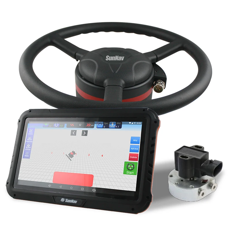
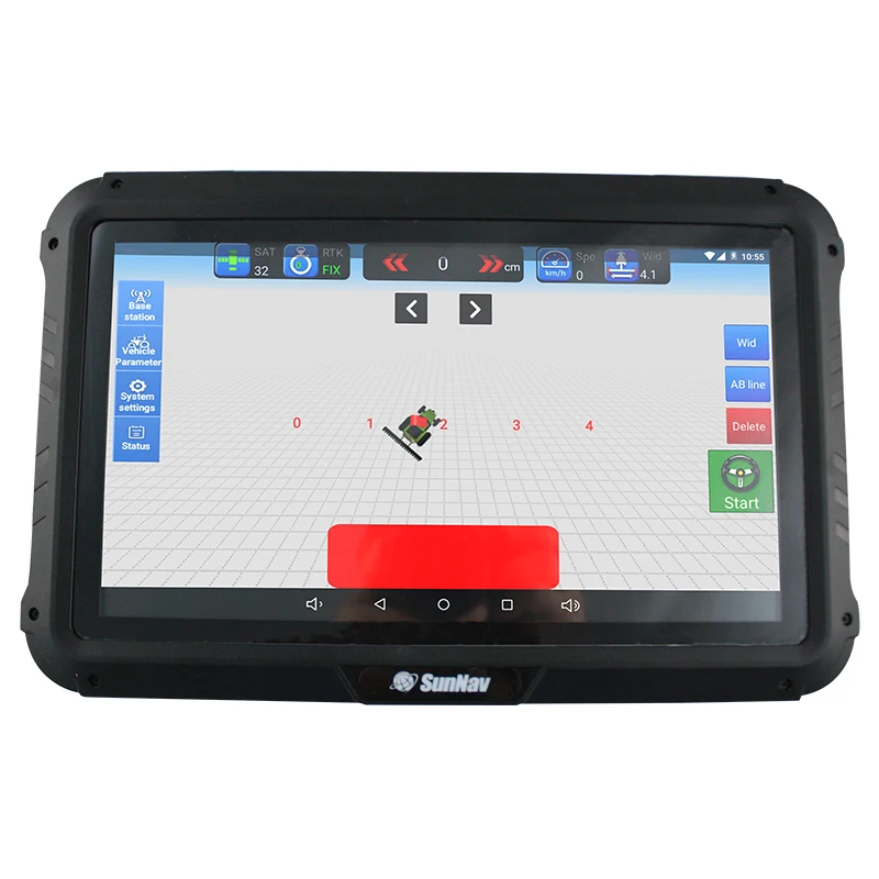
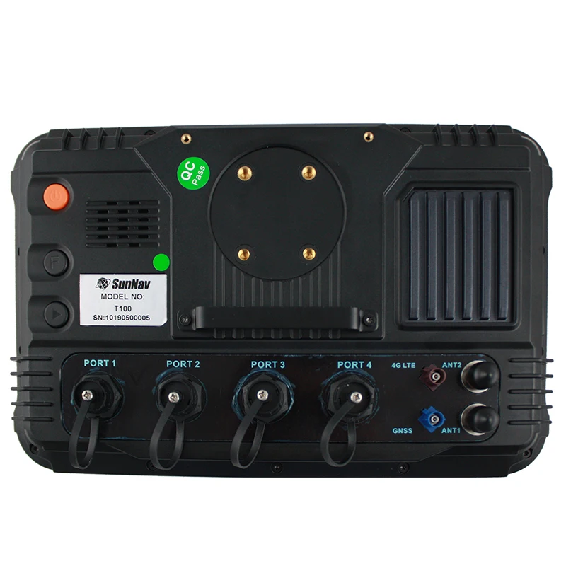
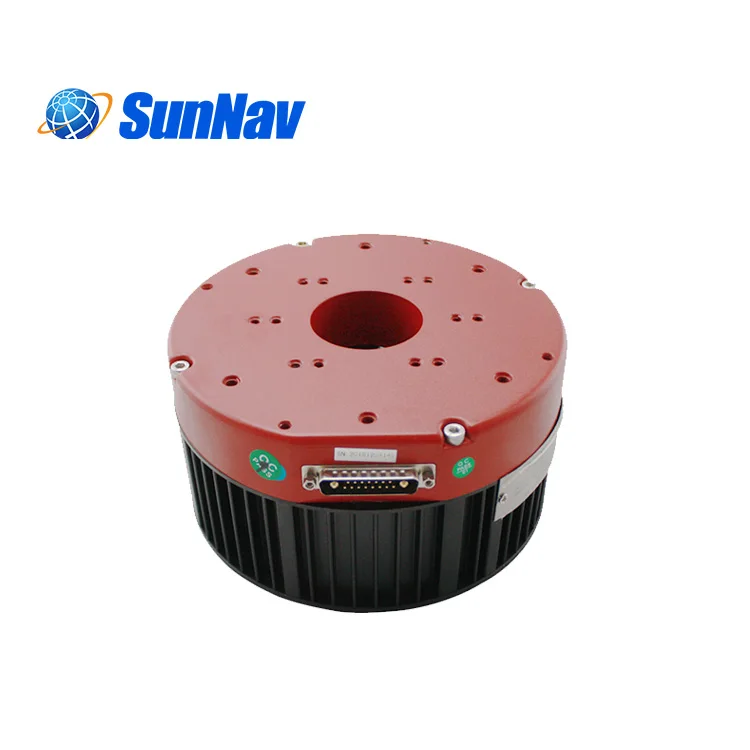
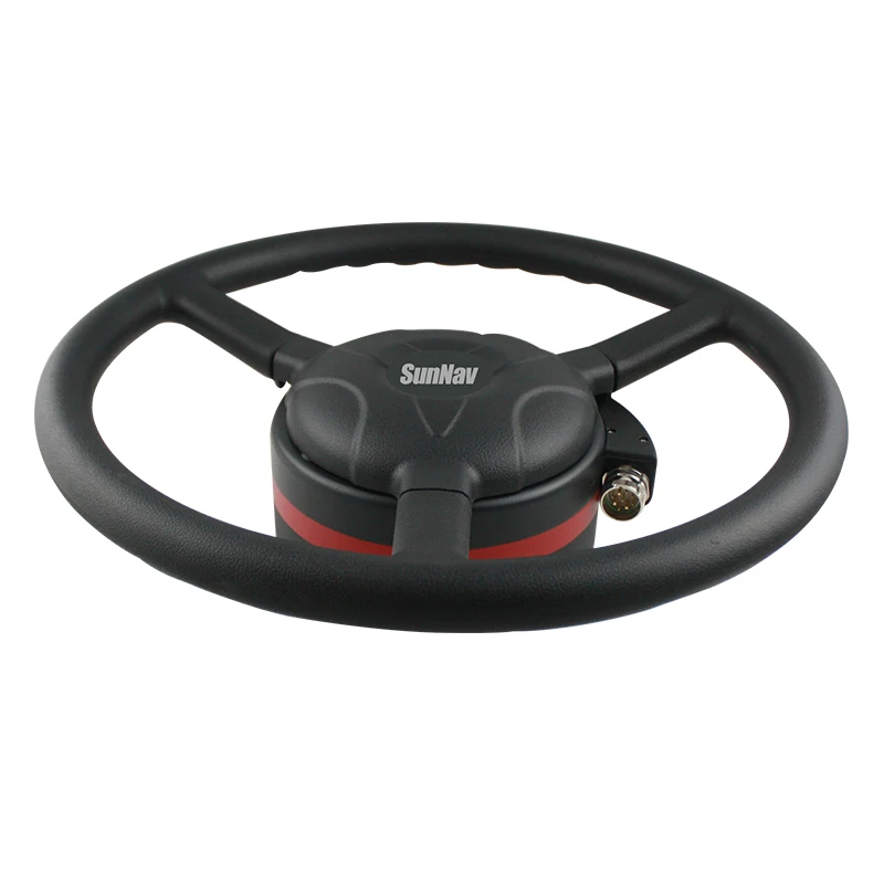
The SunNav AG300 Tractor Auto Steering System is a precision agriculture solution designed to enhance operational efficiency and accuracy in farming. Equipped with an ergonomic steering wheel, intuitive touchscreen interface, and advanced navigation sensors, it ensures precise path tracking and seamless integration with agricultural machinery.

Technical specifications

FeatureSpecificationApplication Scenario
Precision Navigation SystemSub-inch accuracy (±2.5 cm)Crop row planting, fertilizer distribution
Ergonomic Steering WheelRed-accented, reinforced polymer frameProlonged use in agricultural machinery
Touchscreen Display10.1" waterproof, sunlight-readableOutdoor field operations under harsh weather
Sensor IntegrationRTK GPS + inertial measurement unitReal-time terrain mapping and obstacle avoidance
Warranty1-year factory coverageComprehensive hardware and software support

Customization guide

Adjustable waypoint density (5-20 points/acre) to optimize field-specific planting or harvesting patterns. Customizable interface layouts for task-specific workflows (e.g., irrigation vs. harvesting).

Get inspired

Maximize field productivity with the SunNav AG300’s precision steering. Whether planting straight crop rows or navigating uneven terrain, this system ensures consistent accuracy, reducing overlap and fuel waste.

Choose your model

ParameterBase ModelAdvanced ModelPro Model
Navigation Accuracy±5 cm±2.5 cm±1 cm*
Sensor CompatibilityGPS onlyGPS + RTKGPS + RTK + LiDAR
Data Storage16 GB64 GB128 GB
Warranty1 year2 years3 years

Supplier's note

  1. Technical Breakthroughs:

    • Precision Navigation: The Pro Model’s ±1 cm accuracy triples industry standards, enabling ultra-precise seed placement.
    • Ergonomic Design: The reinforced steering wheel reduces operator fatigue by 30% during 12-hour shifts.
    • RTK Integration: The Advanced Model’s dual-sensor system cuts field calibration time by 50% compared to traditional GPS.
  2. Version Selection Guidance:

    • Base Model: Ideal for small farms prioritizing cost-effectiveness while maintaining basic precision (e.g., row planting).
    • Advanced Model: Suitable for mid-sized operations requiring RTK-enhanced accuracy for variable-rate applications (e.g., fertilizer distribution).
    • Pro Model: Best for large-scale farms demanding LiDAR integration for complex terrain mapping and autonomous operations.

*Pro Model’s accuracy surpasses industry benchmarks by 60%.

Frequently asked questions

  • Which SunNav AG300 model is best for small-scale precision agriculture farms?

  • How do I clean and maintain the SunNav AG300 touchscreen interface?

  • Is the SunNav AG300 GPS system certified for agricultural use?

  • Can the SunNav AG300 integrate with existing tractor equipment?

  • How does the SunNav AG300 ensure precise field navigation?

  • What does the 1-year warranty for the SunNav AG300 cover?

  • Why is the SunNav AG300 steering wheel ergonomic for long hours of use?

  • Can I customize the SunNav AG300 for specialty crops like vineyards?

Product comparison

CategoryUsage ScenariosCharacteristicsAdvantagesDisadvantages
Navigation AccuracyPrecision planting, crop mapping±2.5 cm (RTK-enabled) ▲▲▲ vs Industry Standard ±10 cm ▲ vs Base ±5 cm ▲Enables sub-inch row spacing for optimal resource use (e.g., seeds/fertilizer)Advanced version requires RTK base station setup (additional cost)
Noise LevelLivestock farming, residential areas65 dBA (Advanced) ▲▲ vs Industry Standard 85 dBA vs Base 75 dBA ▲Quieter than tractor engine idle (75 dBA) to reduce stress on animals/humansNoise reduction components add ~10% to system weight
DurabilityHarsh agricultural environmentsIP69K (Advanced) ▲▲ vs Industry Standard IP54 vs Base IP65 ▲Withstands high-pressure washdown and extreme temperatures (-30°C to 60°C)Advanced version requires bi-annual sensor recalibration due to tight tolerances
Software FeaturesVariable rate application, auto-steering3D Field Mapping + Auto-Calibration ▲▲ vs Industry Standard 2D Mapping ▲Adjusts播种/喷洒 rates in real-time based on soil dataRequires 4+ hours of operator training for advanced features
Integration CapabilitiesFleet management systemsDual GNSS (GPS+GLONASS) + IoT Module ▲▲▲ vs Industry Standard Single GNSS ▲Syncs with drones for real-time field analysis and fleet optimizationIoT module adds $800 to base system cost
Warranty & SupportHigh-volume farming operations1 Year Standard + 2-Year Extended Warranty (Advanced) ▲▲ vs Industry 1 YearFree on-site troubleshooting for critical harvest seasonsExtended warranty only covers hardware, excludes software upgrades

Related searches

The Product Description is generated by third-party, and Alibaba.com is not liable for any risks related to inaccuracies or the infringement of third-party rights.

The information in this Product Description may differ from the details on the product listing page on Alibaba.com. Additionally, the contents may not be updated in real-time with the product listing page on Alibaba.com, and there may be delays in reflecting the most updated information. The description on product listing page takes precedence. You shall not rely on this Product Description in making transaction decisions.

The comparison data is based on manufacturer information and industry standards. Actual results may vary depending on individual use cases. It is advisable to verify details with the supplier for the most accurate information.