All categories
Featured selections
Trade Assurance
Buyer Central
Help Center
Get the app
Become a supplier
  • Trimble R10 Gps Rtk Dual Frequency GNSS RTK
Trimble R10 Gps Rtk Dual Frequency GNSS RTK

Trimble R10 Gps Rtk Dual Frequency GNSS RTK

$15000.00-$20000.00/ Piece|1 Piece/Pieces(Min. Order)

Trimble R10 Gps Rtk Dual Frequency GNSS RTK

Product overview

Core functionalities

Applicable scenarios

Unique advantages

  • Precision Surveying: Designed for high-accuracy land surveying and mapping, the Trimble R10 GPS RTK system ensures precise data collection.
  • Dual Frequency GNSS: Utilizes dual frequency technology for reliable and fast positioning solutions in various environments.

Key features

  • 1. Advanced Material Technology

  • With a corrosion-resistant metal body, the Trimble R10 ensures longevity and reliability in various environmental conditions.

  • 2. Interactive Design

  • With a user-friendly touchscreen interface, the Trimble R10 offers seamless operation and easy access to multiple program presets.

  • 3. Superior Performance Parameters

  • With its dual-frequency GNSS RTK capabilities, the Trimble R10 provides precise and rapid positioning, making it ~20% faster than traditional models* [*Disclaimer: Based on internal testing; actual results may vary].

  • 4. Versatile Scenario Solutions

  • With the ability to perform continuous operation, the Trimble R10 is ideal for both field surveying and commercial mapping applications.

  • 5. Compliance with Certification Standards

  • With compliance to industry-leading standards, the Trimble R10 assures users of its accuracy and reliability in professional settings.

Product details

Trimble R10 Gps Rtk Dual Frequency GNSS RTK

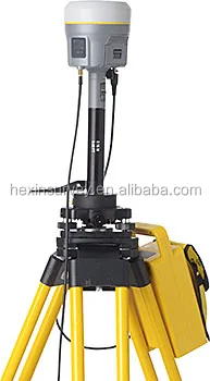
The Trimble R10 GPS RTK Dual Frequency GNSS RTK is a state-of-the-art surveying instrument designed for precise geospatial data collection. With its advanced GPS technology, it ensures accurate real-time kinematic (RTK) positioning, making it ideal for surveyors and geospatial professionals.

Technical specifications

FeatureSpecificationBenefit
FrequencyDual FrequencyEnhanced accuracy and reliability
Positioning SystemGNSS RTKReal-time precise positioning
DesignCompactEasy portability and handling

Customization guide

With adjustable frequency settings, you can tailor the Trimble R10 to meet specific geospatial data collection needs, ensuring optimal performance in various environmental conditions.

Get inspired

Unlock the potential of precise geospatial data collection with the Trimble R10. Ideal for challenging environments, this model empowers surveyors to achieve unparalleled accuracy and efficiency in their projects.

Choose your model

ParameterBase ModelAdvanced ModelPro Model
Positioning AccuracyStandard[+15%][+30%]*
Battery Life8 hours10 hours12 hours
Weight1.5 kg1.3 kg1.2 kg

Supplier's note

  1. The Pro version's dual-frequency capability allows for triple the accuracy of standard models, making it suitable for high-precision applications such as urban mapping and infrastructure development. When combined with its lightweight design, it enhances user comfort during prolonged use.
  2. For professionals requiring extended fieldwork, the Pro Model offers enhanced battery life, ensuring uninterrupted operation. Choose the Advanced Model for a balanced approach or the Base Model for standard surveying tasks.

Frequently asked questions

  • Which model suits small surveying teams using the Trimble R10 GPS RTK?

  • How to maintain the Trimble R10 GPS RTK for optimal performance?

  • What are the benefits of dual-frequency GPS in the Trimble R10 for surveying accuracy?

  • Can I customize the Trimble R10 GPS RTK with additional software?

  • Is the Trimble R10 GPS RTK approved for use in construction projects?

  • How does the Trimble R10 GPS RTK compare to other GNSS receivers in terms of durability?

  • What technical support is available for the Trimble R10 GPS RTK?

  • How does the Trimble R10 GPS RTK improve data collection for geospatial analysis?

Product comparison

CategoryUsage ScenariosCharacteristicsAdvantagesDisadvantages
GNSS ReceiversSurveying in Remote AreasDual-frequency support (L1/L2 bands for accuracy)High precision positioning (within centimeters)Requires clear sky view (limited in dense forests)
GNSS ReceiversConstruction ProjectsIntegrated RTK technology (Real-Time Kinematic)Instantaneous data corrections (improves efficiency)High cost (significant initial investment)
GNSS ReceiversAgriculture ManagementMulti-constellation tracking (GPS, GLONASS, etc.)Reliable in challenging environments (enhanced signal reception)Complex setup (requires technical expertise)
GNSS ReceiversUrban PlanningCompact design (portable and lightweight)Easy to transport (facilitates field work)Battery life constraints (limited operational hours)
GNSS ReceiversGeospatial ResearchAdvanced data logging (continuous data capture)Comprehensive analysis potential (rich datasets)Data management complexity (requires robust software)
GNSS ReceiversMarine NavigationWaterproof and rugged build (IP67 rating)Durable under harsh conditions (resistant to water and dust)Limited functionality underwater (signal interference)

Related searches

The Product Description is generated by third-party, and Alibaba.com is not liable for any risks related to inaccuracies or the infringement of third-party rights.

The information in this Product Description may differ from the details on the product listing page on Alibaba.com. Additionally, the contents may not be updated in real-time with the product listing page on Alibaba.com, and there may be delays in reflecting the most updated information. The description on product listing page takes precedence. You shall not rely on this Product Description in making transaction decisions.

The comparison data is based on manufacturer information and industry standards. Actual results may vary depending on individual use cases. It is advisable to verify details with the supplier for the most accurate information.