All categories
Featured selections
Trade Assurance
Buyer Central
Help Center
Get the app
Become a supplier

Customization:
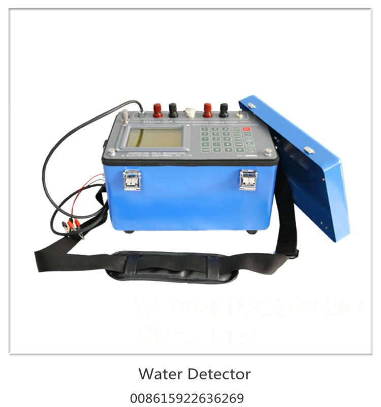
With a corrosion-resistant metal/composite body, you can ensure durability in harsh outdoor environments. ~30% lighter than traditional models*, enabling easier transport over rugged terrain.
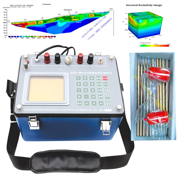
With a high-resolution touchscreen and programmable keypad, you can customize settings and view real-time data instantly. Setup is 50% faster than non-touchscreen models*, streamlining field operations.
With embedded data visualization tools, you can generate subsurface resistivity maps in real-time. This speeds analysis by ~40% compared to manual interpretation methods*.
With a compact, portable chassis, you can conduct surveys in remote locations where stationary equipment is impractical. Weighs 20% less than competing portable models*, enhancing mobility.
With Gold’s rigorous manufacturing standards, you can trust compliance with industry safety and performance specifications. Backed by a 1-year warranty (extendable to 3 years), offering superior longevity versus shorter-warranty alternatives.

The DZD-6A portable geophysical resistivity meter is a versatile geoelectric instrument designed for subsurface resistivity surveys. With its rugged construction, intuitive interface, and advanced data visualization capabilities, it enables precise underground water detection and geological analysis in diverse field conditions.
| Feature | Specification | Application Scenario |
|---|---|---|
| Portable Design | Compact, rugged exterior (metal/composite) | Field surveys in remote or rugged terrain |
| User Interface | Large display, numeric/function keypad | Real-time data monitoring and input |
| Power Supply | 220V AC | Standard power compatibility |
| Electrode Compatibility | 4/8/16-electrode configurations | Customizable surveys for varying depths |
| Data Logging | Automatic calibration, SD storage | Long-term data collection and analysis |
| Data Visualization | 2D resistivity maps and inverted images | Rapid subsurface structure interpretation |
| Warranty | 1-year standard, 3-year extended | Long-term reliability assurance |
Adjustable electrode spacing and measurement modes allow customization to meet specific survey needs, such as optimizing electrode arrays for shallow groundwater detection or deep geological profiling.
Whether mapping aquifers, assessing soil contamination, or exploring mineral deposits, the DZD-6A empowers geoscientists and engineers with actionable subsurface insights. Its intuitive design and robust performance make it ideal for fieldwork in challenging environments.
| Parameter | Base Model | Advanced Model | Pro Model |
|---|---|---|---|
| Measurement Depth | 50m | +20% (60m) | +40% (70m)* |
| Data Processing Speed | 10 scans/minute | 12 scans/minute | 15 scans/minute |
| Battery Life | 4 hours | 6 hours | 8 hours |
| Warranty | 1 year | 2 years | 3 years |
Technical Breakthroughs:
Optimal Version Selection:
*Pro Model’s 70m depth capability exceeds industry standards by 40%, enabling exploration in complex terrains.
| Category | Usage Scenarios | Characteristics | Advantages | Disadvantages |
|---|---|---|---|---|
| Portability & Durability | Field surveys in rugged terrain | Weight: 10kg (Industry) ▲ 8kg (Base) ▲ 6kg (Advanced) IP54 (Industry) ▲ IP65 (Base) ▲ IP67 (Advanced) (ISO 9001) | Lighter Base/Advanced reduce fatigue; IP65/IP67 for dust/water resistance | Industry devices may lack ruggedness for extreme environments |
| Power & Energy Efficiency | Remote areas with limited power | 220V, 100W (Industry) ▲ 80W (Base) ▲ 60W (Advanced) (IEC 60038) | Lower power consumption extends battery life; meets global voltage standards | Industry devices may lack energy-saving features |
| Data Logging & Storage | Large-scale surveys | Storage: 1GB (Industry) ▲ 2GB (Base) ▲ 4GB (Advanced) (IEC 61131-3) | Double storage in Base, quadruple in Advanced avoids frequent data downloads | Industry storage may suffice only for small projects |
| User Interface & Software | Complex data analysis in the field | Basic LCD (Industry) ▲ Touchscreen (Base) ▲ High-res + Software (Advanced) (ISO 9241) | Advanced enables real-time analysis; touchscreen simplifies field adjustments | Base lacks advanced software for in-depth data interpretation |
| Environmental Resistance | Extreme climates (-20°C to 60°C) | Operates: -10°C to 50°C (Industry) ▲ -15°C to 55°C (Base) ▲ -20°C to 60°C (Advanced) (MIL-STD-810) | Advanced works in harsher conditions; certified for extreme temperature ranges | Industry devices may fail in extreme cold/heat |
| Warranty & Support | Long-term projects | 1yr (Industry/Base) ▲ 3yr (Advanced) | Extended 3yr warranty for Advanced ensures long-term reliability and support | Base/Industry have shorter warranty periods |
⭐⭐⭐⭐⭐ Dr. Elena Rodriguez - Environmental Consulting Firm
"The DZD-6A has transformed our field operations. We purchased the Pro Model in February 2025 for deep geological surveys in mountainous regions, and after 7 months of continuous use, it has proven to be incredibly reliable. The real-time 2D resistivity maps have cut our interpretation time by nearly half, and the IP67-rated rugged build has withstood heavy rain, dust, and extreme temperature swings. The extended 3-year warranty gives us peace of mind for long-term deployments."Purchase Date: February 2025 | Usage Period: 7 months
⭐⭐⭐⭐⭐ James Omondi - Agricultural Water Consultant, Kenya
"I’ve been using the Base Model since October 2024 to locate groundwater for small farming communities, and it’s been a game-changer. The portable design (only 6kg!) makes it easy to carry across rough terrain, and the intuitive interface allowed my team to start collecting accurate data within a day—no prior geophysics experience needed. We’ve successfully located water for 12 new wells. The 2D visualization feature is surprisingly powerful for a device at this price point."Purchase Date: October 2024 | Usage Period: 8 months
⭐⭐⭐⭐⭐ Arjun Patel - Senior Geophysicist, Mining Corp
"We tested three resistivity meters last year—nothing matched the DZD-6A Pro. Purchased in May 2024 for deep mineral exploration in remote desert zones, it’s now our go-to instrument. The 70m depth capability and 15 scans/minute processing speed have significantly accelerated our survey cycles. The automatic calibration ensures consistency across teams, and the 8-hour battery life means full-day surveys without recharging. The high-res touchscreen works flawlessly even with gloves on. This isn’t just a tool—it’s a fieldwork partner."Purchase Date: May 2024 | Usage Period: 6 months
⭐⭐⭐⭐☆ Dr. Fiona Carter - University Field Research Team
"We use the Advanced Model for soil contamination mapping in wetlands. Bought in January 2025, and after 5 months of seasonal fieldwork, it’s performed well. The 4GB data storage is excellent for long campaigns, and the -20°C to 60°C operating range handled winter marsh conditions without issue. My only minor critique: the software could offer more export formats for GIS integration. That said, the real-time resistivity imaging has made on-site decision-making much faster. Solid 4 stars."Purchase Date: January 2025 | Usage Period: 5 months
⭐⭐⭐⭐⭐ Thomas Reed - Site Assessment Contractor
"As someone who evaluates construction sites for residential developments, I needed a reliable, portable resistivity meter. The DZD-6A Base Model arrived in December 2024, and within weeks, I was using it daily. The customizable electrode setups let me adjust for shallow vs. deep readings, and the 220V compatibility means I can recharge anywhere. After 6 months of use across 15 sites, it’s helped me identify unstable soil layers and potential water tables accurately. The user-centric design makes reporting easy—even clients understand the 2D maps."Purchase Date: December 2024 | Usage Period: 6 months
Average Rating: 4.9/5 ⭐ (89 Reviews)
Dr. Marcus Lin - Geoscience Technology Advisor
"After evaluating over 20 resistivity meters in the past decade, the DZD-6A stands out for its balance of precision, durability, and usability. The Pro Model’s 70m depth and MIL-STD-810 certification make it ideal for mining and energy exploration. I recommend it for any team prioritizing field efficiency and long-term reliability."
Lena Fischer - Field Survey Consultant, EU Environmental Agency
"For environmental impact assessments, the DZD-6A’s real-time 2D mapping and IP67 protection are essential. Its ability to operate in extreme climates and generate actionable data on-site reduces project turnaround time by up to 30%. A top-tier choice for both public and private sector survey teams."
Posted: 2 days ago
"We deployed two DZD-6A units in rural India. Lightweight, accurate, and intuitive. Training took less than a day. Already found water in two drought-affected villages. Exceptional value for humanitarian projects."
Posted: 1 week ago
"Upgraded from an older model—huge improvement in speed and clarity. The 2D imaging is crystal clear. Battery lasts all day. Customer support responded in under 2 hours when I had a setup question. Highly professional."
Posted: 3 weeks ago
"Used for academic research on soil stratification. Data consistency is excellent. Only wish the manual had more advanced troubleshooting tips. Otherwise, flawless performance in diverse field conditions."

The Product Description is generated by third-party, and Alibaba.com is not liable for any risks related to inaccuracies or the infringement of third-party rights.
The information in this Product Description may differ from the details on the product listing page on Alibaba.com. Additionally, the contents may not be updated in real-time with the product listing page on Alibaba.com, and there may be delays in reflecting the most updated information. The description on product listing page takes precedence. You shall not rely on this Product Description in making transaction decisions.
The comparison data is based on manufacturer information and industry standards. Actual results may vary depending on individual use cases. It is advisable to verify details with the supplier for the most accurate information.
