


Types of Navigation for Skoda
A modern Skoda navigation system plays a crucial role in enhancing driving experience by providing accurate GPS guidance, real-time traffic updates, and seamless integration with smartphones and vehicle systems. Choosing the right type of navigation can significantly improve route efficiency, safety, and convenience for drivers across different Skoda models.
Integrated Navigation Systems
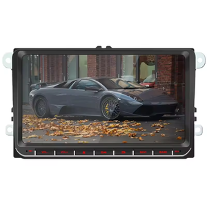
Factory-installed in-dash units that provide native navigation through Skoda’s infotainment interface. These systems are tightly integrated with the vehicle's electronics and often updated via dealer services using USB or SD cards.
Advantages
- Seamless vehicle integration
- Dedicated user interface optimized for Skoda models
- High-resolution maps and clear voice guidance
- Customizable settings within car's infotainment system
Limitations
- Map updates may require dealer visits
- Higher cost to upgrade or repair
- Limited personalization compared to smartphone apps
Best for: Skoda Octavia owners, long-distance drivers, and those who prefer OEM solutions
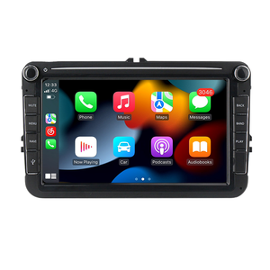
Smartphone Navigation Apps
Skoda SmartLink enables users to mirror their mobile devices and run popular navigation apps like Google Maps, Apple Maps, and Waze directly on the car's touchscreen display.
Advantages
- Familiar interfaces and frequent automatic updates
- Real-time traffic data and alternative routes
- Voice search and POI suggestions based on usage patterns
- Integration with calendar events and saved locations
Limitations
- Requires constant phone connectivity
- Phone battery drain during long trips
- Less immersive than native systems
Best for: Tech-savvy drivers, urban commuters, and those who already rely on mobile navigation
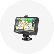
Portable Navigation Units
External GPS devices such as Garmin and TomTom that connect via USB or Bluetooth and offer standalone navigation capabilities without relying on the vehicle's built-in systems.
Advantages
- Easy transfer between vehicles
- Often come with lifetime map updates
- Customizable displays and audible alerts
- Built-in speed limit warnings and camera alerts
Limitations
- Can be visually distracting if poorly mounted
- Additional clutter in the cabin
- Not integrated with vehicle sensors or HUD
Best for: Owners of older Skoda models without factory navigation, rental car users
Web-Based Navigation Services
Cloud-connected systems like HERE WeGo or Skoda Connect that leverage internet access for live map updates, dynamic routing, and real-time traffic information directly from online sources.
Advantages
- Live traffic and weather overlays
- Automatic cloud-based map updates
- Points of interest (POI) and event-based rerouting
- Integration with smart home assistants and other IoT devices
Limitations
- Dependent on consistent internet connection
- Potential data costs with non-unlimited plans
- Slower response times in low-coverage areas
Best for: Skoda Superb and Kodiaq drivers, frequent travelers, and tech-forward users
Voice-Controlled Navigation Systems
Hands-free systems that allow drivers to input destinations and receive directions using natural language voice commands, minimizing distractions and improving safety.
Advantages
- Reduces manual input while driving
- Integrates with virtual assistants like Alexa or Google Assistant
- Fast destination recognition and correction
- Works well with multi-stop routing requests
Limitations
- May struggle with accents or background noise
- Occasional misinterpretation of complex addresses
- Relies on good microphone quality and ambient sound filtering
Best for: Commuters, multitaskers, and drivers prioritizing hands-free operation
Advanced Navigation Systems
Next-generation systems found in electric models like the Skoda Enyaq iV, featuring predictive AI routing, augmented reality overlays, and detailed 3D city visualizations for enhanced situational awareness.
Advantages
- AI-powered route prediction based on habits and traffic
- Augmented reality for turn-by-turn visual cues
- 3D city models for better spatial understanding
- Adaptive energy consumption calculations for EVs
Limitations
- Only available on top-tier models
- High system requirements and processing power
- More expensive maintenance and software licensing
Best for: Skoda Enyaq iV owners, early adopters, and performance-oriented drivers
| Type | Integration Level | Update Frequency | Feature Richness | Recommended For |
|---|---|---|---|---|
| Integrated Navigation | High | Periodic (dealer) | Moderate | Skoda Octavia owners, long-distance drivers |
| Smartphone Navigation | Moderate | Automatic | High | Urban commuters, mobile-first users |
| Portable Navigation | Low | Lifetime updates | Moderate | Rental cars, older models |
| Web-Based Navigation | High | Live updates | High | Skoda Superb/Kodiaq drivers, frequent travelers |
| Voice-Controlled Systems | High | As needed | Moderate | Commuters, multitaskers |
| Advanced Navigation | Very High | Continuous (OTA) | Excellent | Skoda Enyaq iV, tech enthusiasts |
Expert Tip: When using web-based navigation, ensure your Skoda has an active data plan or Wi-Fi connection to avoid interruptions. Also, consider enabling offline maps for areas with poor network coverage.
How to Choose Navigation for Skoda
Selecting the right navigation system for Skoda vehicles intended for business resale involves more than just matching a part number. It requires a deep understanding of vehicle compatibility, customer needs, and technological capabilities. A well-chosen navigation system can significantly enhance the value of a resold vehicle while improving the driving experience.
Understand the Skoda Model and Year
Skoda has produced a wide range of models over the years, each with specific design and electronic architecture considerations. From the compact Fabia to the spacious Kodiaq, each model may require different navigation hardware and software versions. Even within the same model line, features can vary substantially from one production year to another.
- Newer models (2019+) often support touchscreen interfaces and smartphone integration
- Older models may require retrofitting with aftermarket units or factory upgrades
- Some systems are tied to the car's CAN bus network for real-time data display
Pro tip: Check ETKA part numbers for exact compatibility with specific VIN ranges
Map Coverage and Detail Level
The scope and depth of map data directly affect the usefulness of a navigation system. Modern systems offer multi-layered mapping that goes beyond basic route guidance to include detailed environmental information.
- Basic coverage includes major highways and city roads
- Enhanced maps show bike paths, pedestrian zones, and parking areas
- Premium packages add 3D terrain views and building outlines
- Commercial options include truck-specific routes and restrictions
Special consideration: Look for regional map updates if selling internationally
Update Options and Frequency
Modern road networks change constantly, making regular map updates essential. The update method affects long-term usability and customer satisfaction.
- Over-the-air (OTA) updates via Wi-Fi for latest convenience
- USB/DVD-based updates requiring computer access
- Cloud-connected systems with automatic refresh cycles
- Some OEM systems require dealership tools for updates
Key benefit: Systems with free lifetime updates offer better long-term value
Screen Size and Visibility
Display dimensions and visibility characteristics significantly impact usability in various driving conditions. This factor becomes increasingly important as drivers expect smartphone-like interfaces in their vehicles.
- Common sizes: 6.5", 8", 9.2", and 10.25" diagonal displays
- Anti-glare coatings improve readability in direct sunlight
- High-brightness panels maintain visibility at highway speeds
- Adaptive brightness adjusts to ambient light conditions
Visibility test: Evaluate screen performance under simulated daylight conditions
Installation Insight: Factory-installed systems typically integrate seamlessly with existing controls and sensors, while aftermarket units may require additional wiring harnesses or interface modules. Consider offering installation services as an added-value option for your customers.
| Navigation Feature | OEM System | Aftermarket Unit | Portable GPS |
|---|---|---|---|
| Integration | Full dashboard integration | Limited integration possible | Completely standalone |
| Updates | Dealership or OTA updates | User-managed via USB/WiFi | Computer-based updates |
| Price Range | $400–$1,200 | $200–$800 | $100–$300 |
| Installation Time | 2–4 hours (complex) | 1–2 hours (moderate) | Instant (plug-and-play) |
Voice Guidance Capabilities
Voice navigation has evolved beyond simple turn-by-turn instructions to become a sophisticated driver assistance feature. Advanced systems now offer contextual awareness and natural language processing.
- Multilingual voice packs for international markets
- Speed-dependent volume control
- Traffic condition announcements
- Point-of-interest descriptions while driving
Premium feature: Some systems offer celebrity voice options for marketing appeal
Connectivity Options
Modern navigation systems serve as central hubs for digital connectivity, integrating with various devices and services to create a comprehensive infotainment ecosystem.
- Apple CarPlay and Android Auto integration
- Bluetooth pairing for hands-free calling
- Wi-Fi hotspot capability for internet access
- USB-C and wireless charging compatibility
- Vehicle-to-infrastructure communication (V2X)
Marketing advantage: Highlight smartphone mirroring capabilities for tech-savvy buyers
Budget Guidance: When working with price-sensitive customers, consider recommending entry-level systems with core functionality that can be upgraded later through software updates. This approach provides immediate value while maintaining upgrade potential without full hardware replacement.
Frequently Asked Questions About Navigation Systems
A1: Typically, navigation maps should be updated every 3 to 5 years to ensure optimal performance and accuracy. However, the exact timeframe depends on several variables such as:
- Rate of infrastructure changes: Areas undergoing rapid development or road construction will require more frequent updates.
- Usage frequency: If you rely heavily on your navigation system for daily travel, outdated maps can cause increasing inconvenience over time.
- Data availability: Some regions receive map data updates more frequently than others due to manufacturer support and mapping provider resources.
To maintain the reliability of your navigation system, it's wise to check for map updates annually, especially if you drive in urban or changing environments.
A2: Updating a vehicle’s navigation system involves acquiring and installing the latest map data and software. The process typically includes the following steps:
- Check compatibility: Ensure that your device model supports updates and identify the current version installed.
- Obtain the update: Updates may be available through multiple channels:
- Direct download from the manufacturer’s official website
- Purchase via USB drive (common with older systems)
- Over-the-Air (OTA) updates for newer vehicles with wireless connectivity
- Installation: Follow the specific instructions provided by the manufacturer. This could involve connecting your car to a computer, inserting a USB drive into the vehicle, or initiating an automatic OTA installation.
Some premium systems offer subscription-based services for automatic periodic updates, ensuring minimal user effort and maximum convenience.
A3: Yes, outdated maps can significantly impair navigation performance in several critical ways:
- Inaccurate routing: Missing new roads or closed highways can lead to incorrect turn-by-turn directions and longer travel times.
- Missing points of interest (POIs): New businesses, gas stations, restaurants, and other locations won't appear, limiting the system's usefulness.
- Traffic issues: Outdated systems might not recognize new traffic patterns or congestion-prone areas, leading to inefficient route planning.
- Safety concerns: Lack of information about one-way streets, speed limits, or recent detours can pose safety risks.
Keeping your maps up-to-date ensures safer, faster, and more efficient journeys, particularly when traveling in unfamiliar areas or where infrastructure changes are frequent.
A4: In most cases, yes—users can perform navigation updates themselves without needing professional assistance. Car manufacturers often provide clear, step-by-step guidance for updating maps and software. Here’s how you can typically proceed:
- Visit the manufacturer's website: Locate the support or downloads section for your specific vehicle make and model.
- Download or order the update: Some updates are free, while others require purchase. You may receive them via USB, SD card, or direct download.
- Follow installation instructions: Each system has its own method—some plug directly into the car, others need to be synced via Bluetooth or Wi-Fi.
While the process is usually straightforward, always double-check the model compatibility and backup any personal settings before proceeding. If unsure, consult your local dealership or service center for help.
A5: Regularly updating your navigation system offers numerous advantages that enhance both functionality and driving experience:
- Improved route accuracy: Updated maps reflect the latest road conditions, ensuring more reliable directions and estimated arrival times.
- New Points of Interest (POIs): Discover recently opened businesses, charging stations, rest stops, and emergency services.
- Better traffic handling: Real-time traffic features work more effectively with updated road databases, helping avoid delays.
- Software enhancements: Many updates include bug fixes, interface improvements, and even new features like voice control or integration with smartphone apps.
- Long-term system health: Keeping your system updated helps maintain overall performance and extends the usability of your vehicle’s infotainment suite.
| Benefit | Description | Impact |
|---|---|---|
| Route Accuracy | Up-to-date road networks and closures | Fewer detours, better time management |
| POI Updates | New restaurants, hotels, EV charging stations | More convenient stops and services |
| Traffic Integration | Real-time traffic flow based on current conditions | Reduced congestion and fuel savings |
| System Performance | Bug fixes, UI improvements, and security patches | Smaller risk of crashes or glitches |
Ultimately, regular navigation system updates contribute to a safer, smarter, and more enjoyable driving experience—especially for frequent travelers or those who depend on their vehicle for business use.