


Specifications and Maintenance of the VW Polo Navigation System
Key Specifications to Consider
When selecting or upgrading a navigation system for your Volkswagen Polo, understanding the core specifications ensures you choose a system that aligns with your driving needs, preferences, and vehicle compatibility. Here's an in-depth look at each key feature:
Display Quality
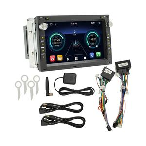
The visual interface is crucial for usability. VW Polo systems typically offer display sizes ranging from 6.5” to 9.2”, with HD resolution becoming standard in newer models.
A high-resolution touchscreen with anti-glare coating enhances visibility under bright sunlight and provides sharper map details. Touch responsiveness and intuitive UI design also contribute significantly to user experience.
Mapping Capabilities
Volkswagen’s MIB (Modular Infotainment Matrix) systems come preloaded with European maps, often including detailed coverage of cities, rural roads, and points of interest (POIs).
Consider systems offering over-the-air updates or SD card-based map upgrades. Some premium packages include real-time traffic overlays and predictive route suggestions based on historical traffic patterns.
GPS Receiver Performance
A built-in GPS receiver with multi-satellite support (GPS, GLONASS, Galileo) ensures faster signal acquisition and more accurate positioning, even in urban canyons or tunnels.
Higher-end units may integrate dead reckoning technology using wheel speed sensors and gyroscopes to maintain navigation accuracy when satellite signals are temporarily lost.
Voice Control Integration
VW’s voice control allows drivers to input destinations, search POIs, and adjust settings using natural language commands like "Navigate to Munich Central Station."
This feature reduces driver distraction and promotes safer operation while driving. Advanced systems recognize regional accents and support multiple languages for broader accessibility.
Bluetooth Connectivity
Modern VW navigation systems support dual Bluetooth pairing, allowing connection of two smartphones simultaneously for seamless switching between devices.
Beyond hands-free calling, Bluetooth enables wireless audio streaming and integration with smartphone apps through MirrorLink or Android Auto/Apple CarPlay (depending on system version).
Real-Time Traffic Updates
This feature uses live traffic data from sources like TomTom or HERE Technologies to provide up-to-date congestion alerts and suggest alternative routes dynamically during navigation.
Some systems combine this with predictive analytics to anticipate delays before they occur, helping you maintain punctuality even during peak hours.
| Feature | Benefits | Recommended Configuration |
|---|---|---|
| Touchscreen Display | Enhanced usability and visual clarity | Minimum 8” capacitive touchscreen with HD resolution |
| Map Update Frequency | Ensures accurate routing and location data | Annual map updates via SD card or OTA |
| GPS Antenna Placement | Optimal signal reception and accuracy | Rooftop or windshield-mounted antenna for best performance |
| Voice Recognition Accuracy | Reduces manual interaction while driving | Natural language processing with multi-language support |
| Integration Options | Connectivity with modern mobile devices | Support for Apple CarPlay, Android Auto, and MirrorLink |
Essential Maintenance Practices
To keep your VW Polo navigation system functioning at its best, regular maintenance and proper care are essential. Follow these expert-recommended practices:
Important: If you encounter persistent issues such as freezing screens, inaccurate navigation, or connectivity problems, avoid DIY repairs unless you have specialized automotive electronics knowledge. Visit an authorized Volkswagen service center for diagnostics and professional repair services to maintain warranty compliance and system integrity.
How to Choose VW Polo Navigation System
Selecting the right navigation system for your Volkswagen Polo involves more than just picking a screen with the most features. The ideal system should align with your driving habits, budget, and long-term usage needs while ensuring seamless integration with your vehicle's existing electronics.
Model and Year Compatibility
Volkswagen has offered various infotainment systems across different Polo generations. It’s crucial to match the navigation system to your specific model year to ensure proper fitment and functionality.
- Polo Mk5 (Typ BE/BL): Common systems include Composition Media or Discover Media
- Polo Mk6 (Typ AQ-F): Typically comes with MIB2 or MIB2+ infotainment platforms
- Check if the system is CANBUS compatible with your VIN-specific configuration
Pro tip: Use your VIN number to cross-reference compatibility with OEM or aftermarket suppliers.
Screen Size and Interface Preferences
The size of the touchscreen and its interface significantly affect usability and visual clarity while driving. Larger screens generally offer better readability but may require dashboard modifications.
- Standard units: 6–6.5” displays with basic touch controls
- Upgraded options: 8–9.2” high-resolution capacitive touchscreens
- Advanced features: Gesture control, voice commands, split-screen mode
Consider: Touchscreen responsiveness, glare reduction, and glove-friendly operation
Mapping Coverage and Updates
Navigation accuracy depends heavily on map quality and update frequency. Systems vary in terms of pre-installed regions and update mechanisms.
- Basic models: Limited to Western Europe coverage
- Mid-range: Full European maps including Eastern Europe
- High-end: Worldwide maps with satellite imagery and terrain views
Update note: Some systems allow over-the-air updates, while others require SD card or USB transfers
Connectivity Options
Modern navigation systems often integrate with smartphones and cloud services. Connectivity affects both real-time traffic data and future-proofing potential.
- Wi-Fi enabled systems for OTA updates
- Bluetooth + CarPlay/Android Auto support
- Embedded SIM cards for live traffic and POI downloads
Important: Verify network compatibility if using embedded connectivity solutions
Budget Guidance: While higher-end systems come with premium features, consider whether all functions are necessary for your use case. For example, an embedded SIM card might be unnecessary if you regularly tether via smartphone. Balance initial cost with expected lifespan and feature utilization.
| Feature Level | Typical Screen Size | Map Coverage | Update Method | Average Cost Range |
|---|---|---|---|---|
| Entry-Level | 6-6.5" | Western Europe | USB / SD Card | €200 - €350 |
| Mid-Range | 8" | Europe-wide | Wi-Fi / USB | €400 - €600 |
| High-End | 9.2" | Worldwide | OTA / Embedded SIM | €700 - €1,200+ |
Installation Complexity
Not all navigation systems install as direct replacements. Consider your technical ability and whether professional installation will be required.
- OEM units often plug directly into existing wiring
- Aftermarket systems may need harness adapters or new mounting kits
- Larger screens might require dashboard trimming or bezel replacement
DIY tip: Look for systems with ISO connectors or DAB antenna integration if retaining radio features
Accessories and Expandability
A well-designed system should allow for future upgrades or additional components that enhance functionality.
- External GPS antennas for improved signal reception
- Additional cameras (reverse, front, 360° view)
- Amplifier/DSP integration for audio enthusiasts
- Optional steering wheel control modules
Long-term value: Choose systems with modular design for easier future enhancements
Performance Tip: Always verify if the navigation system supports firmware customization or third-party app integration. These features can extend the system's usefulness far beyond basic mapping and route planning capabilities.
Frequently Asked Questions about VW Polo Navigation System
The VW Polo's navigation system includes functionality for pedestrian navigation in certain models and software versions. To use this feature, access the route planning menu and select "walking mode" or a similar option to calculate routes optimized for foot traffic. This mode typically avoids highways and prioritizes sidewalks, crosswalks, and pedestrian paths.
It’s particularly useful in urban environments where drivers may park their car and continue on foot to reach their destination. The system might also integrate with smartphone apps via Car-Net services to provide seamless transitions between vehicle and pedestrian navigation.
Volkswagen recommends updating your Polo's navigation maps at least once annually to ensure optimal performance and accuracy. Map updates typically include:
- Newly constructed roads and infrastructure changes
- Updated speed limits and traffic regulations
- Revised points of interest (POIs) like gas stations, restaurants, and service centers
- Improved routing algorithms for better travel time estimates
Some newer models support over-the-air (OTA) updates, while others require purchasing an SD card or USB update from authorized dealers. Always check your owner's manual or contact VW customer support for specific instructions based on your model year and infotainment version.
If you encounter inaccurate navigation guidance in your VW Polo, follow these troubleshooting steps:
- Verify map data: Ensure your system has the latest map updates installed.
- Check GPS signal: Park in an open area away from tall buildings or tunnels that might interfere with satellite reception.
- Recalibrate location: Use the 'Recalibrate' function in the settings menu to realign the vehicle's position on the map.
- Confirm input: Double-check that the entered address or POI is correct and not misinterpreted by the system.
- Reset the system: Perform a soft reset by turning off the ignition and restarting the infotainment system.
If issues persist after these checks, consult the official VW user manual or contact your nearest dealership for diagnostic testing and potential software reinstallation.
The core functionality of the VW Polo navigation system operates independently of an internet connection using preloaded map data. However, certain advanced features do require online connectivity:
| Feature | Requires Internet? | Description |
|---|---|---|
| Basic Navigation | No | Standard route calculation using onboard maps |
| Real-time Traffic Updates | Yes | Live traffic data to avoid congestion and optimize routes |
| Online Map Updates | Yes | Download latest map versions without physical media |
| Points of Interest (POI) Search | Yes (optional) | Access cloud-based databases for current business listings |
| Car-Net Services | Yes | Remote access features through the We Connect app |
Connectivity can be established through your smartphone's hotspot or built-in SIM card (depending on model specification). Without internet access, you'll still have full access to offline navigation capabilities.
If your VW Polo's navigation system experiences glitches or unresponsiveness, try these reset methods:
Soft Reset Procedure:
- Press and hold the power button for 10 seconds until the screen turns off
- Wait 10-15 seconds before powering it back on
- This resolves most temporary software issues
Factory Reset (Use with Caution):
- Access settings menu → System → Reset
- Select "Factory Settings" to restore default configuration
- Note: This will erase personal preferences and saved locations
Hardware Reset (if applicable):
For older models experiencing persistent problems:
- Turn off the engine and remove the key
- Disconnect the vehicle battery for 15 minutes
- Reconnect and restart the system
If resets fail to resolve issues, seek professional assistance from an authorized VW service center for deeper diagnostics and potential component replacement.